The Poison Spider Trail is an intriguing destination for paleontology enthusiasts and outdoor adventurers alike. Anyone will be fascinated with the numerous dinosaur tracks embedded in the rock formations along the path. These tracks, which date back millions of years, provide valuable insights into the behavior and movement patterns of dinosaurs that once roamed this region.
Check out the size and shape of the tracks. Educate yourself about the different types of dinosaurs believed to have made these tracks and details about the geological processes that have preserved them over time.
This might be one of your best hikes in Moab!
Table of Contents
Map Of Poison Spider Trail
About Poison Spider Trail
- Address: Along Potash Road, west of Moab, Utah
- Trailhead GPS: 38.53239373257896, -109.60929521477647
- Amenities: Vehicle parking, vault toilets, and dog-friendly
- Level: Moderate
- Length: 0.3 miles
- Estimated Time: 9 minutes
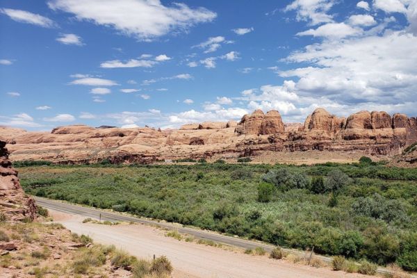
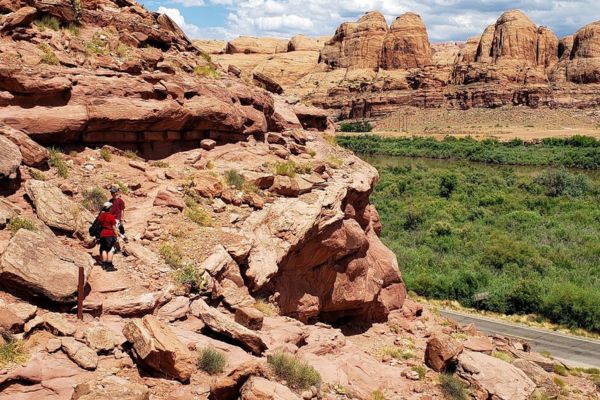
The Poison Spider Trail begins at the trailhead, which offers views of the Colorado River. The path is open all year round, and dogs are welcome, but they must be leashed.
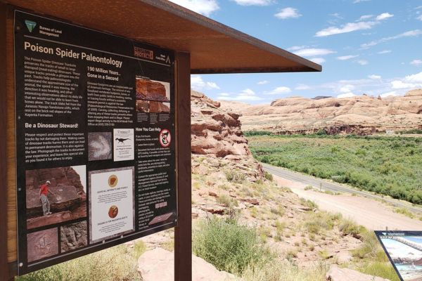
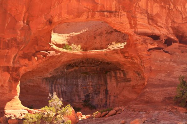
The Navajo Sandstone represents a massive sand dunes environment or erg. This sand desert covered most of Utah and portions of New Mexico, Arizona, Colorado, and Wyoming around 90 million years ago. Little streams, shallow ponds, and sporadic flat regions of moist sand were between the dune fields.
The tracks that dinosaurs left behind as they walked across these flats were occasionally preserved completely and covered up by the sand dunes. After millions of years, when the sands had turned to stone, and chunks holding the tracks had fallen out of the cliffs above and split along the bedding planes, the traces were once again exposed to sunlight.
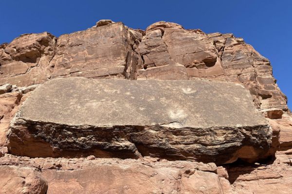
From the parking lot, you can see two big, flat granite slabs with footprints: one at the foot of the cliffs and another halfway down the hill, right above the precipice that plunges into the road. At least ten distinct meat-eating dinosaurs, with hip lengths varying from 17 inches to more than 5 feet, have left their footprints on the lowermost of these slabs.
Theropod dinosaurs, bipedal carnivores, left behind the tracks. Eubrontes is the name of the larger tracks, and Grallator is the name of the smaller courses. It looks like the animals were moving at about three miles per hour.
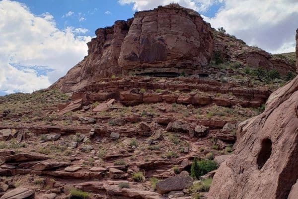
The lower slopes and the parking area are part of the Kayenta Formation, but the blocks bearing the tracks have collapsed from the Navajo Sandstone cliffs above. The Navajo Sandstone exhibits angled crossbedding, which is indicative of sand layers that were deposited by wind.
Guided Tour of Poison Spider Trail
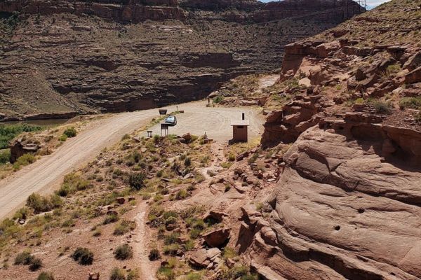
The Poison Spider Dinosaur Tracksite trailhead is ten miles from Moab’s city along Rt 279/Potash Rd. A kiosk at the trailhead provides useful information about the location.
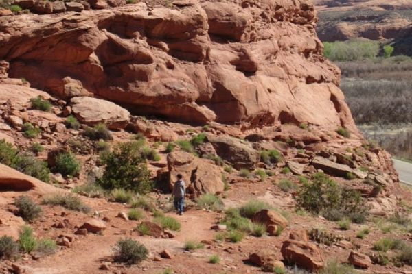
The trail begins its climb up the edge of the formation after a few hundred feet. About one-third of the way up, the trail skirts the side of a large sandstone slab containing two extremely well-preserved theropod tracks—theropods were a common dinosaur in the area in the Late Jurassic Period. A sign next to the tracks tells you more about the dinosaur that left them.
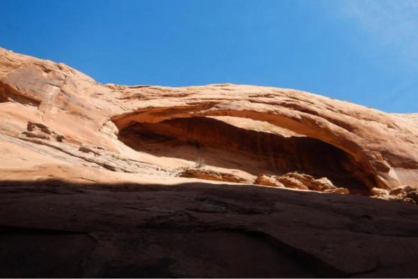
Once the trail passes by the Longbow Arch spur trail, it continues past the dinosaur tracks and climbs up to a ledge close to the summit of the structure. When you go to the edge, there’s a little petroglyph panel with pictures of sheep and two human-like creatures, one with a headdress. Proceeding left along the cliff, you’ll come onto an interesting panel with six human-like figures holding hands and images of sheep, concentric circles, and a very big serpent.
Even for people who are afraid of heights, there is enough room on the ledge to wander about and explore. The panel there has an odd depiction of a two-headed sheep to the left. Moving along the cliff, you’ll come to a panel with a multitude of human-like individuals, some of which have headdresses, as well as a variety of animals, a scene from a hunting expedition, and other images.
You will see another panel with some quite intriguing graphics after this one. Interestingly, two of the animals appear to have hammer-like features on their heads, one animal is shown with a bow and arrow, a sheep has its front two feet wrapped, and there’s an unidentified animal to the left of the panel with two humps and an elongated neck. There’s also a picture of a scorpion on the panel, close to the right side.
A little down the cliff is a boulder displaying two sheep arranged crookedly, with their backsides rubbed against one another. These are not the only pictures along the ledge; many more are worth looking at (and I suggest you should!). After exploring to your heart’s content, just follow your route back to the trailhead.
What To Expect on Your Hike
If you’re short on time, you can see the petroglyphs and dinosaur tracks in no more than 30 minutes. In fact, the dinosaur tracks are visible from the Poison Spider Mesa parking lot’s north side.
It’s obvious that people have been aware of these dinosaur footprints for a very long period. They look like plaster was poured into them to create molds of the tracks because they have been scraped and scratched repeatedly. Although these are incredibly amazing to witness, they have seen better days due to their extreme accessibility.
Please be mindful of and respect this tracksite. Take only pictures. In the past, visitors trying to make unauthorized casts have destroyed some of these tracks.
It’s not too bad when you can view some great petroglyphs and dinosaur tracks with very little effort. It becomes clear why people visit the area when adding a few arches and picturesque canyons to the mix.
How To Find The Poison Spider Trailhead
Travel northwest on US 191 from Moab to UT 279/Potash Road, which turns left (south) at 1.3 miles west of the Colorado River Bridge. After six miles of traveling south on UT 279, make a right turn at the Poison Spider Mesa trailhead designated for mountain bikes, ATVs, and jeeps.
Side Note: UTV and ATV rentals in Moab are a must-try! With so many fantastic trails, it only seems right to cruise around in your own UTV or ATV.
Proceed 0.1 miles along the little dirt path to reach a spacious parking lot featuring a pit toilet and an information kiosk. On the lot’s north side lies the Dinosaur Track trailhead.
What Time is The Busiest?
The busiest time to hike the Poison Spider Dinosaur Tracksite Trail can vary depending on several factors, including the season, weather conditions, and local events. Generally, popular hiking trails like this one tend to be busiest during weekends, holidays, and peak tourist seasons.
In places like Moab, Utah, which experiences a surge in visitors during the spring and fall due to milder temperatures, you might find more crowds on the trail during these seasons. Additionally, early mornings and late afternoons are typically less crowded than midday, as many hikers prefer to avoid the heat of the day.
If you’re looking to hike the Poison Spider Trail during a quiet time, consider visiting on weekdays or during the off-season. However, be sure to check local park regulations and trail conditions before planning your visit, as factors like weather and maintenance schedules can also affect trail usage.
Flying A Drone (Is It Allowed?)
The Poison Spider Dinosaur Tracksite is located at Poison Spider Mesa, which is regulated by the Bureau of Land Management (BLM). Before flying a drone in the Poison Spider area, it’s crucial to research and understand any restrictions or prohibitions regarding drone usage in the region. Some common regulations related to drone flying in outdoor recreational areas include:
- Prohibition in certain areas: Drones might be prohibited in certain parts of the trail due to safety concerns, environmental protection, or interference with wildlife.
- Licensing and permits: Some areas require individuals to obtain permits or licenses before flying drones, especially for commercial purposes.
- Flight altitude and distance: There might be restrictions on the maximum altitude and distance a drone can be flown from the operator, particularly in areas near airports or sensitive wildlife habitats.
- Respect for wildlife and other visitors: Drones must be operated responsibly, avoiding disturbances to wildlife and respecting the privacy and safety of other visitors.
To ensure compliance with regulations and respect for the environment and other trail users, it’s advisable to contact BLM directly. They can provide specific information on drone regulations and any permits required for flying drones in the area. Additionally, signs or information boards at the trailhead may provide guidance on drone usage policies.
Other Hikes Close To Poison Spider Trail
The Poison Spider Mesa is overseen by the Bureau of Land Management (BLM). It is located beside the most famous national parks in Moab, UT, known for their hiking trails. Here are some of the trails along Arches and Canyonlands that are near the Poison Spider Dinosaur Tracksite.
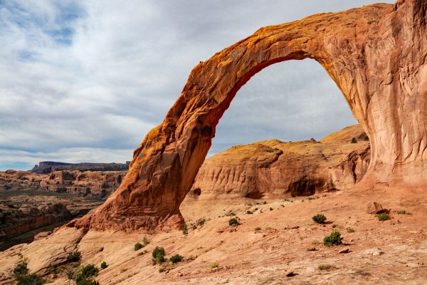
Longbow Arch Trail
- Level: Moderate
- Length: 2.2 miles
- Estimated Time: 2 hours
The Longbow Arch Trail starts at the Poison Spider trailhead, which is located just west of Moab, Utah, along Highway 279, also known as the Potash Road, close to the Colorado River.
The short route begins with an exciting climb up a section of slickrock, followed by a short stretch of rebar steps set into the sandstone that offers easy access to the region above through a breach in the cliff. The climb then continues over sandy washes and across domes of slickrock until it reaches Longbow Arch.
Corona Arch
- Level: Moderate
- Length: 2.3 miles
- Estimated Time: 2-3 hours
The Corona Arch Trail is one of Moab’s most well-liked and rewarding walks, and it’s right outside Arches National Park. The trail winds through a stunning yet untamed environment with sand washes, high cliffs, and multicolored slickrock. It passes Pinto Arch and Bowtie Arch on the route.
The breathtaking 140-foot-long and 105-foot-tall Corona Arch, also known as Little Rainbow Bridge, is a natural sandstone arch. With breathtaking vistas, it rises magnificently at the end of the walk.
Pinto Arch Trail
- Level: Moderate
- Length: 0.6 miles
- Estimated Time: 1 hour
Pinto Arch is on the Corona Arch Trail west of Moab, Utah. Almost half a mile into the wildly popular Corona Arch route is where the trail to this arch starts.
From there, one must traverse slickrock and areas of wind-blown sand to reach a remote location, which is the only spot where the small little arch is visible. Along with beautiful views of the Colorado River meandering through the canyon below, hikers can also enjoy various alcoves with hanging gardens with ferns, orchids, and columbines.
What to Bring On Your Hike
When preparing for a hike at the Poison Spider Dinosaur Tracksite Trail or any similar outdoor adventure, it’s essential to pack wisely to ensure a safe and enjoyable experience. Here’s a list of items you might consider bringing:
Water: Staying hydrated is crucial, especially in desert environments like Moab. Bring an adequate amount of water for your hike, considering the length and difficulty of the trail.
Snacks: Pack lightweight, energy-boosting snacks like trail mix, granola bars, or fruit to keep you fueled throughout the hike.
Sun Protection: Wear sunscreen, sunglasses, and a wide-brimmed hat or cap to protect yourself from the sun’s harsh rays.
Appropriate Footwear: To navigate the rocky terrain safely, choose sturdy, comfortable hiking shoes or boots with good traction.
Weather-Appropriate Clothing: Dress in layers and wear moisture-wicking clothing suitable for the weather conditions. Consider bringing a lightweight rain jacket or windbreaker in case of unexpected weather changes. Remember, you’re in the desert, and you’ll be hiking on top of large rock formations!
Navigation Tools: Carry a map of the trail and a compass or GPS device to help you navigate. Familiarize yourself with the trail beforehand and follow any posted signs or markers.
First Aid Kit: For minor injuries or emergencies, pack a basic first aid kit containing essentials such as bandages, antiseptic wipes, adhesive tape, and pain relievers.
Camera or Smartphone: Use a camera or smartphone to capture the stunning scenery and memorable moments along the trail. Believe me when I tell you there are lots of petroglyphs and dinosaur tracks to photograph!
What People Are Saying About Poison Spider
The Poison Spider Trail is popular for hiking, off-roading, and mountain biking in Moab. Therefore, people have lots of good things to say about it. Here are some of them:
This is a quick detour to do while in Moab – we just went to the parking lot and hiked 0,5 miles to the dinosaur foot print. there is longer hike but we just wanted a quick stop
the road to go there is very nice along the Colorado river
Plus it is FREE
J-P D – Tripadvisor
A fun little scramble up to the Dino tracks, then keep going left a bit to see the petroglyphs. I did it with a sleeping baby attached to me so relatively safe. It’s a must visit–super cool!
Lu Hunnicutt – AllTrails
Poison Spider dinosaur trackway has some of the best dinosaur tracks we’ve ever seen. As a bonus, there are beautiful, mostly undisturbed petroglyphs along the route there.
Natalie Ockey – Utah’s Adventure Family
Learn About The Poison Spider Dinosaur Tracks
Exploring the Poison Spider Dinosaur Tracksite Trail offers a physical adventure and a journey through time, allowing visitors to connect with the distant past and gain a deeper appreciation for the wonders of the natural world. Located in the breathtaking landscapes of Moab, Utah, this trail offers a glimpse into the ancient past, showcasing dinosaur footprints preserved in stone.
Whether you’re a seasoned hiker, a budding paleontologist, or simply someone who enjoys exploring the great outdoors, this trail is sure to leave a lasting impression. It’s also great to know that it’s easy!
Poison Spider Trail FAQs
How hard is the Poison Spider Trail?
The trail is considered moderate in difficulty, featuring some rocky and uneven terrain with moderate elevation changes. While it may present challenges for beginners or those not accustomed to hiking, it is manageable for most reasonably fit individuals.
What can you see at Poison Spider Trail in Moab?
Hikers along the Poison Spider Dinosaur Tracksite Trail can explore stunning desert landscapes, including towering red rock formations and expansive views of the surrounding area. The main highlight of the trail is the opportunity to view dinosaur tracks preserved in stone, offering a glimpse into the ancient past. These tracks provide valuable insights into the behavior and movement patterns of dinosaurs that once roamed the region.
Is it worth hiking the Poison Spider Dinosaur Tracksite Trail?
Absolutely! Hiking the Poison Spider Dinosaur Tracksite Trail offers a unique and memorable outdoor experience, combining natural beauty with fascinating historical significance. The chance to see dinosaur tracks up close and immerse yourself in the rugged beauty of Moab’s desert landscape makes it a worthwhile adventure for anyone visiting the area.