
I swear you’ll never see something as majestic as this. The Upheaval Dome Trail provides views of a remarkable geological feature: a mile-wide crater of enigmatic origins, either generated by a salt dome that formed deep under the earth or a meteorite that struck and spat forth a large splash of minerals.
People are still debating as to why the Upheaval Dome looks like that. But there’s no debate as to why this might be Utah’s most interesting geological feature. Find out why.
Table of Contents
Map Of Upheaval Dome Trail
About Upheaval Dome Trail
- Address: Island In The Sky, Canyonlands National Park
- Trailhead GPS: 38.426315, -109.926110
- Website: nps.gov/places/upheaval-dome-overlook-trails.htm
- Hours: Open year-round, 24 hours a day
- Arches National Park Admission: Per Person: $15 | Motorcycle: $25 | Private Vehicle $30
- Amenities: Restroom and scenic photo spot
- Level: Easy-Moderate
- Length: 1.7 miles
- Estimated Time: 45 minutes
There is relative geologic order in Canyonlands. Sedimentary deposit layers methodically document historical events in the park. In the millions of years since ancient seas, rivers, or winds laid them down, these layers—with a few notable exceptions—have not undergone substantial alterations, tilts, or folds.
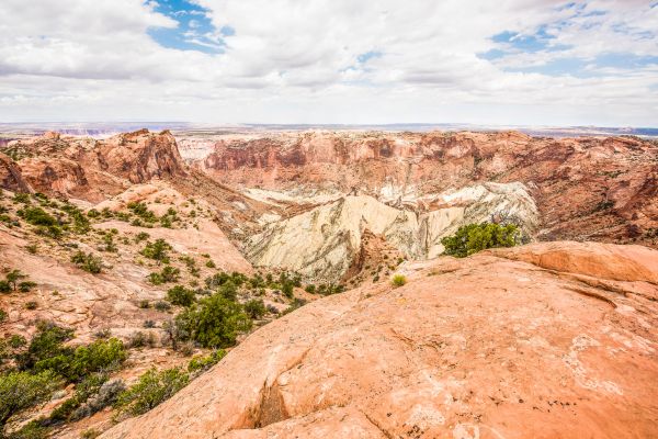
That is a whole different tale for Upheaval Dome. The granite layers are significantly deformed at approximately three miles (5 km) broad. The rocks are forced upward into a circular formation known as an anticline or a dome in the center. A syncline, or downwarp in the rock layers, envelops this dome. What led to the Upheaval Dome folds? Although there are two main theories that are vigorously contested, geologists are unsure.
The Salt Dome Theory
A large portion of southeast Utah and Canyonlands National Park are covered in a thick layer of salt that was created by the evaporation of ancient landlocked seas. The underlying rock, which is thousands of feet thick, can exert pressure on the salt, causing it to flow flexibly like glacial ice. Furthermore, salt has a lower density than sandstone. Because of this, salt has the ability to pass through rock strata as a “salt bubble” over millions of years, rising to the surface and causing salt domes that distort the nearby rock.
When geologists initially proposed that Upheaval Dome originated from a salt dome, they thought the landform was the product of rock layers eroding above the dome. According to a recent study, erosion may have completely destroyed the salt bubble and the rock covering it; the current surface of Upheaval Dome is thought to be the pinched-off stem beneath the absent bubble.
If confirmed, Upheaval Dome would hold the title of the planet’s most extensively eroded salt dome.
Impact Crater Theory
Like the well-known impact crater in Arizona, meteorites leave behind their tracks when they collide with the Earth. According to some geologists, the Upheaval Dome was struck by a meteorite about 60 million years ago, with a diameter of about one-third of a mile. The hit produced a massive explosion, shooting dust and debris high into the atmosphere.
An unstable crater that was first generated by the impact partially collapsed. The rocks beneath Upheaval Dome rose upward to fill the hole left by the impact as the surrounding area stabilized. Any meteorite debris has been swept away by erosion after the impact, revealing rock layers that were formerly buried thousands of feet underground and offering a view into the impact crater’s core.
Currently…
Recent scientific findings support the meteorite hypothesis, yet unanswered questions remain. Upheaval Dome is a protected geologic laboratory located within Canyonlands National Park, where anybody can learn about and be inspired by nature’s mysteries. Perhaps we will eventually unravel the mystery of this crater and others on Earth.
Guided Tour Of Upheaval Dome Trail
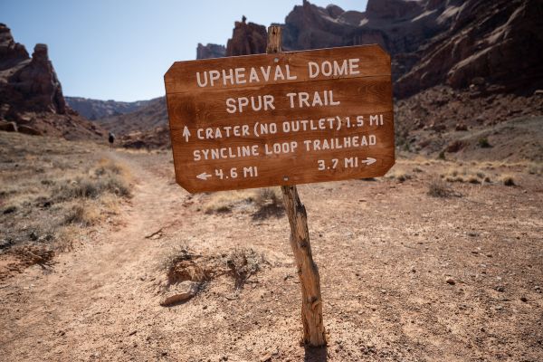
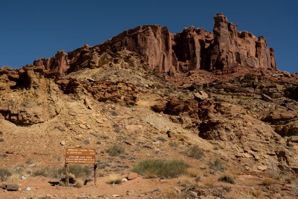
The northwest corner of the picnic area, close to the explanatory board, is where the trail starts. For several hundred feet, Upheaval Dome Trail and Syncline Loop run parallel to one another; however, at a junction, turn right to reach Upheaval Dome. There’s a continuous hike up to the first viewpoint.
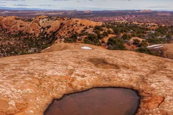
Look back to see views of the park road and the peaks of the La Sal Mountains rising up to the east in the distance. Pileon trees, junipers, and Mormon tea are all in your path ahead. After cresting a slope, proceed on the slickrock trail.
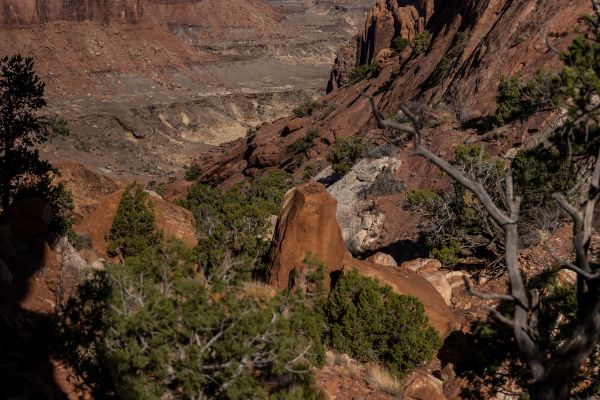
When you come to a sign for the first viewpoint, go right and travel approximately 150 feet to the hike’s high point and vista. Here, uniform rock layers found elsewhere in the park are forced up into radically overturned strata. The main dome, a massive belly button encircled by a rust-colored ring, rises 750 feet above the ground. It is greyish in color.
Go back the way you came to reach the main route and head west to reach the second viewpoint. Traverse gently undulating slickrock hills on a cairned path. Once you get to a saddle, ascend and cross the next dome. At around 0.8 miles, the trail veers to the northeast, crosses the crater rim, and arrives at the second viewpoint. Go back the same way you came.
What To Expect on Your Hike
If you’re trekking to the overlooks, pack at least a quart of water, sunscreen, and a wide-brimmed hat, as this trail does not have shade.
Upheaval Dome’s trailhead is located in a picnic area at the end of Upheaval Dome Road. Because there aren’t many parking spots, you might have to park on the shoulder of the road and walk a few hundred feet to get to the trailhead.
You begin at Upheaval Dome, where there is a sign and image. There isn’t another trailhead. Once you start hiking from here, you’ll pass a junction with the Syncline Loop Trail, which is a breathtaking and amazing full-day hike that descends into the Upheaval Dome. Rest assured, large signs will alert you if you inadvertently stray from the “easy” portion of the trail.
How To Find Upheaval Dome Trailhead
After 11 miles of traveling north on US 191 N (Main Street), turn left (west) onto UT 313 W. Travel 14.6 miles on UT-313 W to the “Y” intersection, where UT-313 makes a left turn. After traveling 13.1 miles straight on Grand View Point Road/Island in the Sky Road, head right onto Upheaval Dome Road.
Travel 4.8 miles on Upheaval Dome Road until you reach the trailhead parking area for Syncline Loop and Upheaval Dome. The route begins at the northwest corner of the parking lot. The path is broad and simple to navigate.
What Time is The Busiest?
We advise doing most of your hiking early in the morning to avoid the heat, as temperatures here may often reach over 100 degrees throughout the summer.
At the first overlook, you might observe a dozen or more people; however, on the route to the second overlook, you might only see one or two others.
Flying A Drone (Is It Allowed?)
Launching, landing, or operating unmanned aircraft (such as drones, quadcopters, or model airplanes) is prohibited in Upheaval Dome Trail at Canyonlands National Park. The National Park Service (NPS) imposes restrictions on drone usage to protect wildlife, preserve natural quiet, and ensure visitor safety.
Other Hikes Close To Upheaval Dome Trail
After seeing the best views in Upheaval Dome, you might be interested in exploring other trails nearby. They also offer the best Canyonlands hikes and the best views in Moab!
Syncline Loop Trail
- Level: Hard
- Length: 7.9 miles
- Estimated Time: 5-7 hours
We’re starting off strong! Upheaval Dome can be viewed from the Syncline Loop Trail; however, it’s not visible from the trail. It demands climbing and scrambling across boulder fields and has sharp turns. The majority of park rescues occur on this trail, which is also the hardest in the Island in the Sky region.
Hiking the path counterclockwise begins with an extremely steep fall. But for greater afternoon shade, make your way slowly up across miles and miles of soft sand.
Whale Rock Trail
- Level: Easy
- Length: 0.8 miles
- Estimated Time: 1 hour
This trail climbs the side of a sandstone dome and ends with sweeping views of the Island in the Sky. It’s excellent for children who enjoy climbing rocks.
This region has many features and creative names. Thus, the long sandstone dome might look like a giant whale. See for yourself! This path follows its lateral flank before ascending from the “tail” to the “blowhole.”
Alcove Spring Trail
- Level: Hard
- Length: 11 miles
- Estimated Time: 6-7 hours
Although this path is popular with backpackers and hikers, you can still find solitude during the day. You can visit the trail at any time of year because it is always stunning. The trail descends past a large nook before winding its way to the foot of the well-known Moses and Zeus towers across a broad canyon.
What to Bring On Your Hike
When hiking the Upheaval Dome Trail in Canyonlands National Park, it’s essential to come prepared for the unique challenges and environment of the trail. Here’s a specific list of items to bring:
Water: The desert climate can be unforgiving, so bring plenty of water. Aim for at least 1 gallon (3.8 liters) per person for a day hike.
Sturdy Hiking Shoes: The terrain, with rocky sections and uneven surfaces, can be rugged. Good hiking shoes or boots with ankle support are crucial.
Sun Protection: Protect yourself from the intense desert sun with sunscreen, sunglasses, and a wide-brimmed hat or cap.
Snacks/Energy Food: Keep your energy up with lightweight, high-energy snacks like trail mix, energy bars, or dried fruits.
Map and Compass/GPS: While the trail is marked, it’s always a good idea to have navigation tools in case you stray off course.
First Aid Kit: Prepare for minor injuries with a basic first aid kit that includes bandages, antiseptic wipes, pain relievers, and personal medications.
Trash Bag: Pack out all your trash to help keep the trail clean. A lightweight trash bag is handy for carrying out any garbage you generate during your hike.
Camera or Smartphone: Capture the stunning views along the trail with a camera or smartphone. Just be sure to pack it securely to protect it from bumps and falls.
What People Are Saying About Upheaval Dome Trail
There are numerous hikes in Moab that fascinate lots of people. Upheaval Dome has a different story because it’s really the “talk of the town” due to its unique features. Here’s what others are saying about this trail:
Unique geological site with awesome views. I went to both of the viewpoints. First viewpoint is great but I’m glad I went to the second viewpoint too as I feel you get an even better “whole” view.
JW041 – Tripadvisor
Cool trail. Feels like you’re on a different planet in some parts. Just follow the cairns and look for the arrows to stay on the trail. Great views from the top!
Mindy Gregorsok – AllTrails
Great photos are to be had from either overlook. It’s difficult to understand the immensity of Upheaval Dome until you see it!
Adam – Your Hike Guide
Marvel At The Upheaval Dome Overlook
The Upheaval Dome Trail in Canyonlands National Park offers a fascinating journey through a geological marvel. As you hike, take a moment to soak in the vastness of the canyon and the unique rock formations that define the area.
The highlight of the Upheaval Dome Trail is reaching the main overlooks, which offer incredible views of the Upheaval Dome itself. Scientists have a mystery about this geological formation, and theories range from an eroded salt dome to an impact crater. Regardless of its origin, the Upheaval Dome is a sight to behold, with its concentric rings and dramatic rock layers.
Upheaval Dome Trail FAQs
How do I get to Upheaval Dome?
To reach Upheaval Dome in Canyonlands National Park, you’ll need to drive to the Island in the Sky district. From the visitor center, follow the signs to Upheaval Dome. The trailhead is located at the end of Upheaval Dome Road, where you can park your vehicle and begin your hike.
Where is the Upheaval Dome located?
Upheaval Dome is located in Canyonlands National Park in southeastern Utah, United States. It is situated in the park’s Island in the Sky district.
How old is the Upheaval Dome?
The age of Upheaval Dome is still a subject of scientific debate and research. While it’s difficult to determine an exact age, geological studies suggest that Upheaval Dome maybe tens of millions of years old.
What is the mystery of Upheaval Dome?
The mystery of Upheaval Dome lies in its unique geological structure and origin. Various theories about how Upheaval Dome formed exist, including erosion of a salt dome, a collapsed cavern, or even an impact crater from a meteorite. However, no single theory has been universally accepted, making Upheaval Dome a subject of ongoing scientific inquiry and fascination.
Which of the layers of Upheaval Dome are most resistant to erosion?
Within Upheaval Dome, the harder and more resistant rock layers typically erode more slowly, creating the distinctive concentric rings or layers seen in the formation. These resistant layers can include sandstone, limestone, or other sedimentary rock types that are more durable and less susceptible to weathering and erosion compared to surrounding layers.