
The Corona Arch Trail in Moab, Utah, is challenging (if you’re a newbie hiker) but very much rewarding. It’s located in the Colorado Plateau near the Colorado River, making it a popular destination for hikers, photographers, and nature enthusiasts.
The Corona Arch Trail receives significant foot traffic throughout the year, particularly during the peak tourist seasons. While its visitation numbers may not be as high as those of the Arches and Canyonlands national parks – which could reach up to a million visitors per year – it is still a popular destination for those seeking to experience the unique beauty of the Moab area.
Let’s look at how its accessibility, iconic landmark status, and other characteristics contribute to its popularity among travelers to the region.
Table of Contents
Map Of Corona Arch Trail
About Corona Arch Trail
- Location: 38°34’28.0″N 109°37’56.5″W
- Address: 10 miles west of the Utah 279/US 191 junction near Arches National Park, on Utah Scenic Byway 279
- Amenities: There are restrooms just past the trailhead parking area at the Gold Bar Campground on the river side of the road. The trail is not wheelchair-accessible.
- Level: Moderate
- Length: 2.3 miles Out And Back
- Estimated Time: 2-3 hours
Corona Arch Trail is a hike located just outside Arches National Park and is one of Moab’s most popular and rewarding hikes. The trail takes you through a rugged and beautiful landscape featuring colorful slickrock, sandy washes, and towering cliffs. Along the way, it passes Pinto Arch and Bowtie Arch.
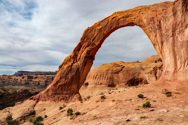
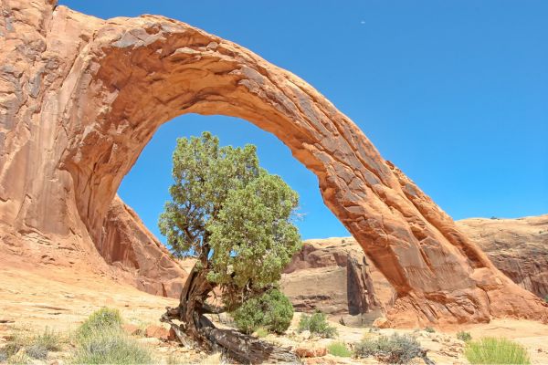
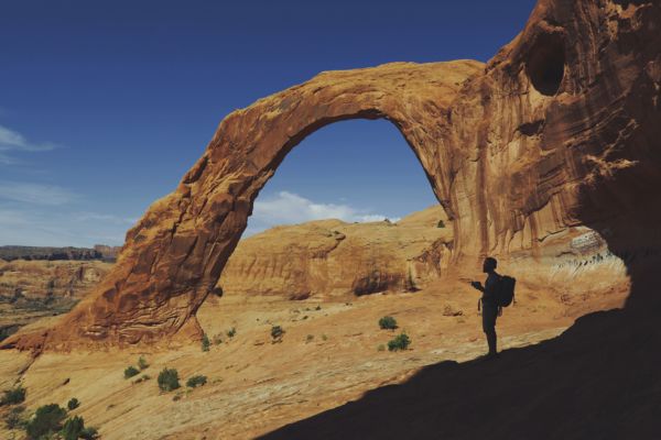
Corona Arch, also called Little Rainbow Bridge, is a stunning natural sandstone arch with a span of 140 feet and a height of 105 feet. It stands majestically at the end of the trail, offering jaw-dropping views.
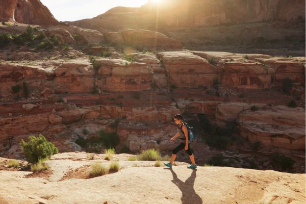
The hike is considered moderately challenging due to a few sections with steep drop-offs, areas with ladders and cables for assistance, and uneven terrain.
The roundtrip distance is around 3 miles. Most hikers take about 2-3 hours to complete the Corona Arch Trail. This allows ample time to enjoy the scenery, take breaks, and capture plenty of photos.
If you have a fear of heights (like me) or mobility limitations, you may want to enjoy the view of Corona Arch from a distance, as parts of the trail can be challenging for those with these concerns.
About Bowtie Arch
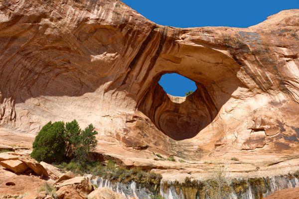
Located along the Corona Arch trail, Bowtie Arch gets its name from its distinctive shape, resembling a bowtie. It is smaller in size compared to Corona Arch but still impressive in its own right.
The arch is formed from the same red sandstone that characterizes the region’s geological features. You can view Bowtie Arch from the trail as you make your way to Corona Arch.
About Pinto Arch
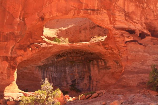
Like Bowtie Arch, Pinto Arch is smaller than Corona Arch but offers its own unique charm. They say the arch gets its name from its resemblance to a pinto horse. Its distinctive pattern and shape add to its appeal. You can enjoy views of Pinto Arch as you hike along the trail towards Corona Arch.
Guided Tour Of Corona And Bowtie Arch Trail
Two of Moab’s most striking natural beauties are Corona Arch and Bowtie Arch. When you search for things to do in Moab, most results focus on hiking in the nearby National Parks, Arches, and Canyonlands.
But if you get to the point of this article, you probably know by now that the Corona and Bowtie Arch Trails are a great experience as well. It is a fantastic choice for hikers of all ages and skill levels. Compared to other nearby national park hikes, the arches are less busy and easily accessible. Did I also mention that it’s free?
It’s best to hike to Corona Arch at sunrise or sunset. But I would say that hiking the Corona and Bowtie Arch Trail at sunset is the ideal choice, even though Corona Arch is equally stunning at morning.
Another advantage of hiking the Corona and Bowtie Arch Trails around sunset is the fewer crowds. Most people will be racing towards Corona Arch at first light or attempting to return to their cars before nightfall. It’s rewarding to sit and watch the sun set over the canyon – I almost can’t describe the feeling.
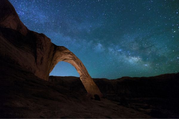
If you linger a bit longer at the destination, you will be among the select few to see the Corona Arch illuminated by a Moab starry sky at dusk. It’s also one of the best places for stargazing in Moab.
Remember that this trail is narrow and easy to follow but a little trickier than your typical trail. There are moments when the path widens significantly as you navigate slickrock slabs. Remember to follow any rock cairns you come across and pay attention to the blue and green paint marks on the rock.
You will cross two short wire sections before they can reach Bowtie Arch and Corona Arch. Although the cable parts are not very technical, they do provide comfort when hiking over exposed and steep areas.
You will also ascend a short ladder to reach the last step over the ledge and onto the rock bench where Bowtie Arch and Corona Arch are situated. The arches are still visible throughout the entire ascent of the ladder, but there is still some distance to cover. The juniper tree adjacent to the ladder should be noted since it serves as a useful marker while locating the ladder at night.
The canyon that encircles both Arches is, in my opinion, what makes the Corona and Bowtie Arch Trail so compelling. It’s difficult to tell where to look until you turn the bend at the end of the hike—Bowtie Arch, Corona Arch, or Bootlegger Canyon.
What To Expect on Your Hike
Though it passes several extensive sections of slickrock pavement, the Corona Arch trail is easy to follow. Nonetheless, cairns are used to clearly identify these areas. Metal wires can be used as handrails in a couple of the slickrock areas, and there is a ladder on one steep step. As I’ve noted earlier, you can just turn around and see the arch after the first cable if you’re afraid of heights!
I highly recommend taking this hike early in the morning during the warmer months because it receives constant sunlight. Wear a cap and bring lots of water with you. There is only so much shade along the walk if it is late in the afternoon when it is beneath overhanging rocks. If you’re bringing kids with you, keep an eye on them as the path passes by several steep drops.
Proceed from the trailhead located on the right side of the parking lot. At 0.1 mile, the trail abruptly climbs a rocky talus slope and comes to a BLM register box just before the train tracks. Register, then proceed across the tracks.
Just a little educational info: Trains transport potash from North America’s largest potash deposit, the Potash Mine, via the train tracks. Potash is extracted via solution mining, processed, and transported by truck and railroad as fertilizer and water softener.
The sandy trail heads north along an old road against a cliff before bending to the right beneath it. A pothole arch known as Pinto Arch can be seen by looking up left to the high canyon wall.
The track travels northeast across sand and slickrock pavement until it’s beneath a huge slabby cliff. It climbs up a short rocky canyon to a broad bench. Below the cliff, trek on uneven slabs to a long cable that is anchored to posts.
Your first sight of the majestic Corona Arch, which spans Bootlegger Canyon, is 0.7 miles past the cable. This is the ideal time to change your mind if you’re afraid of heights!
The trail then bends left along a broad stone bench and crosses another cable made of slickrock pavement. Reach for the cable and ascend the steps carved out of a slab of rock. Ascend the five-step metal staircase above to a higher bench and a small, twisted juniper tree. Proceed towards Corona Arch by following the wide slickrock bench that circles the top of a cul-de-sac canyon.
To your left, Bowtie Arch looms over the route. An arch was created when a pothole above—typically filled with water—eroded down into a cave below. After 1.5 km, continue climbing down a steep slab of sandstone to reach Corona Arch.
Now, you’ve reached Corona Arch!
Retrace your steps to the trailhead to complete the hike.
How To Find The Corona Arch Trailhead
To find the trailhead for the Corona Arch hike in Moab, Utah, follow these directions:
- From Moab, head north on US-191 for approximately 4.5 miles.
- Look for a sign indicating the Potash Road (also known as Utah State Route 279) on your right. Turn right onto Potash Road.
- Follow Potash Road for about 10.2 miles until you reach a signed parking area on the left side of the road. This parking area is known as the Corona Arch Trailhead.
- Park your vehicle in the designated parking area.
- The trailhead is well-marked, and the trail starts from the parking area. Look for signs indicating the start of the hike to Corona Arch.
Please note that Potash Road is a scenic byway that runs alongside the Colorado River, offering stunning views of the surrounding red rock cliffs and canyonlands. The drive itself is part of the experience and adds to the adventure of reaching the Corona Arch trailhead.
What Time is The Busiest?
Generally, the trail tends to be busiest during the spring and fall months, when the weather is mild and comfortable for hiking. Weekends and holidays also tend to draw larger crowds to such a popular hiking destination so you may encounter more people on the trail during these times.
Additionally, the busiest times of day typically coincide with peak visitor hours, which are usually late morning to early afternoon. Many visitors prefer to hike during these hours to avoid the heat of the midday sun, so the trail may be more crowded during this time.
If you prefer a quieter hiking experience, consider visiting the trail during weekdays or early in the morning before the crowds arrive. Regardless of when you choose to hike, arriving early can help you beat the crowds and enjoy the trail at your own pace.
Are Drones Allowed On This Hike?
Adventurers use the arch for thrills and excitement, but it doesn’t have the same protections as its federally sheltered neighbors because it’s outside of Arches National Park.
You can fly drones in Corona Arch, but I recommend not doing so for preservation and safety.
Furthermore, you should know that passing through the arch with an aircraft and rappelling up and down it is no longer permitted. However, climbers continue to reach the summit and rappel down, and airplanes have been known to pass through the gap.
What to Bring On Your Hike To Corona Arch
When embarking on a hike to Corona Arch, it’s essential to come prepared with the right gear and supplies to ensure a safe and enjoyable experience in the desert environment. Here’s a list of items that I think you should consider bringing to be really prepared:
- Water: Hydration is crucial, especially in the desert heat. Bring plenty of water to stay hydrated throughout the hike. A general recommendation is to carry at least one liter of water per hour of hiking.
- Snacks/Food: Pack energy-boosting snacks and a light meal if you plan to spend several hours on the trail. Trail mix, granola bars, and fresh fruits are convenient options.
- Sun Protection: Protect yourself from the sun’s harmful rays by wearing sunscreen with a high SPF rating and reapplying it regularly. A wide-brimmed hat, sunglasses, and lightweight clothing that covers your skin can also help prevent sunburn.
- Footwear: Choose sturdy and comfortable hiking shoes or boots with good traction for navigating rocky terrain. Avoid open-toed shoes or sandals, as they offer little protection and can be uncomfortable on uneven surfaces.
- Navigation: Carry a map of the area or use a GPS device or smartphone app to help navigate the trail. While the trail to Corona Arch is well-marked, having a backup navigation tool can be helpful, especially if you plan to explore further.
- First Aid Kit: Pack a small first aid kit containing essentials such as adhesive bandages, antiseptic wipes, pain relievers, and blister treatment. Be prepared to treat minor injuries or discomforts that may arise during the hike.
- Emergency Supplies: Bring a fully charged cell phone and consider carrying a portable charger or power bank for extended hikes. Additionally, include items like a whistle, flashlight, and lightweight emergency blanket in case of unexpected situations.
- Trash Bag: Practice Leave-No-Trace principles by collecting all trash and disposing of it properly. Bring a lightweight trash bag to pack out any waste generated during your hike.
- Camera/Phone: Use a camera or smartphone to capture the stunning scenery and memorable moments along the trail. Remember to be mindful of your surroundings and fellow hikers while taking photos.
By packing these essential items and being prepared for the conditions you may encounter on the trail, you can make the most of your hike to Corona Arch while staying safe and comfortable.
What People Are Saying About Corona Arch Trail
Corona Arch Trail is a very popular area for hiking, so you’ll likely encounter other people while exploring. Here’s what others are saying about this trail:
Beautiful trail. Trail is as dry and no problems. Not as strenuous as some have reported. Some may be a bit nervous on the chains or ladders but it wasn’t hard to navigate.
Great hike up the hill, over the train tracks, through the sheep gates, up the chain, climb the ladder, and over the slick rock. A large spectacular walk under arch. Nice in late afternoon. The bonus was the Bow Tie Arch nearby
Corona Arch may not be part of the Arches National Park, but it’s definitely one of the best arches in the Moab area!
David & Intan – The World Travel Guy
Don’t Miss Out On Hiking The Corona Arch Trail
The stunning Corona Arch is made of Navajo sandstone. On hot days, lie down under the arch in its long, narrow shade to truly appreciate its immensity and fragility. Make sure to take in every moment you spend there.
Both Bowtie Arch and Pinto Arch contribute to the scenic beauty of the Corona Arch trail, providing hikers with additional opportunities to appreciate the natural wonders of the Moab area. While Corona Arch may be your primary destination, exploring these smaller arches along the way adds to the sense of adventure and discovery that makes the hike memorable.
Corona Arch Trail FAQs
How long is the hike to Corona Arch?
The hike to Corona Arch is approximately 2.3 miles round trip, taking around 2-3 hours to complete. The trail is considered moderate in difficulty, with some rocky terrain and moderate inclines along the way.
Is Corona Arch worth visiting?
Yes, Corona Arch is definitely worth visiting. It’s a stunning natural wonder with a unique shape and impressive size, standing at about 140 feet tall and spanning 105 feet across. The hike to Corona Arch offers breathtaking views of the surrounding red rock formations and provides an opportunity to experience the beauty of the Utah desert up close.
Is Corona Arch inside Arches National Park?
No, Corona Arch is not located inside Arches National Park. It is situated in the Moab area, near the Colorado River, and falls within the jurisdiction of the Bureau of Land Management (BLM).
Is Corona Arch better at sunrise or sunset?
Both sunrise and sunset can offer beautiful lighting conditions for photographing Corona Arch. Ultimately, the best time to visit Corona Arch depends on personal preference and the experience you’re looking for. Keep in mind that sunrise hikes may be less crowded compared to sunset, offering a more peaceful and immersive experience in nature.