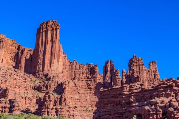
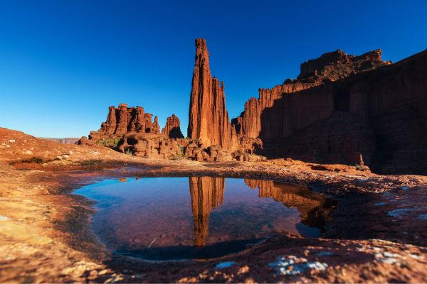
Hiking the Fisher Towers Trail allows you to explore one of the most unusual sights in Utah’s canyon country: the Fisher Towers. East of Moab, the towers are a tangle of towering fins, pinnacles, minarets, gargoyles, spires, and oddly shaped rock formations. They are made of tougher Moenkopi sandstone on top of darker Cutler sandstone and are covered in mud curtains. They are imposing monuments to erosion.
Interested in seeing them for yourself? Then, you need this guide to take one of the best hikes in Moab.
Table of Contents
Map Of Fisher Towers Trail
About Fisher Towers Trail
- Address: Fisher Towers Rd, Moab, UT 84532, USA
- GPS: Parking Lot (38.725073°, -109.308962°); The Kingfisher (38.72272, -109.30264); Cottontail Tower (38.71946, -109.30273); The Titan (38.717082°, -109.299503°)
- Amenities: Vehicle parking, portable toilets, and dog-friendly
- Level: Hard
- Length: 5.2 miles
- Estimated Time: 2 to 3 hours
Organ Rock Tongue from the Cutler geologic formation and Moenkopi formation rock on top make up the Fisher Towers. The Towers are the solitary remains of the Uncompahgre highland in western Colorado, with its floodplain deposit dating back 225 million years. The salt deposits beneath the Colorado Plateau bent, twisted, and crumbled when it was raised. Erosion led to the creation of cliff escarpments and valleys.
Three Colorado men climbed the 900-foot Titan, the highest tower, for the first time in 1962. Due to recent advancements in climbing techniques and equipment, rock climbing is becoming rather widespread in this area despite the less-than-ideal conditions provided by the towers’ crumbly texture.
The 2.6-mile trail winds around the towers, making a 5.2-mile round-trip trek as it dips into jagged gorges and passes under sheer cliff faces. That being said, you are free to trek as far as you like before returning to the trailhead by retracing your steps.
A lot of day hikers finish their journey at the base of Cottontail Tower’s west ridge, which is a 0.5-mile one-way hike, or at the ridge under Ancient Art, a rock formation with a peak curved like a corkscrew.
Guided Tour Of Fisher Towers Trail
Start your hike of Fisher Towers Trail at the parking lot and trailhead to the north of the area. The trailhead has a trail marker, registration, and pit toilet. There’s a small BLM campground nearby.
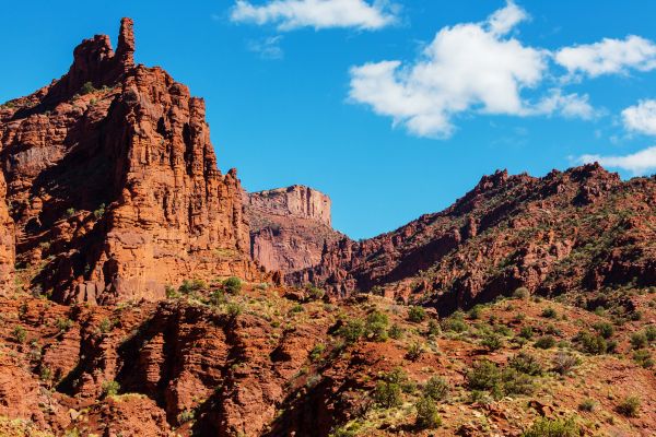
The trail lowers into a canyon, over slickrock, and descends a short slope. It travels around the west side of Ancient Art at the bottom before climbing out of a side canyon. The trail comes to a viewpoint south of Ancient Art after 0.75 km. A left-hand climber’s track leads to the spire.
The trail meanders through a canyon before descending steep slopes beneath the 800-foot-tall spire known as Cottontail Tower. After a mile, the trail comes to the foot of Cottontail’s steep west ridge. This is a nice place to rest because of the bedrock. Hikers often do a U-turn at this point and trek back to the trailhead.
Dogs are permitted on leashes. However, around 1.5 miles into the route is a little ladder that could be challenging for a large dog to climb.
The following section of the route dips into a canyon and proceeds eastward on a granite bench beneath Cottontail’s precipitous south face. Enter the canyon by descending a six-step metal ladder, then proceed into another canyon by following the trail that winds around steep slopes.
Beyond this point, the path ascends gradually around The Titan, the tallest of the Fisher Towers and a well-liked climbing route for rock climbers. Around the base of The Titan, at a distance of 2.0 kilometers, the trail skirts across an exposed ledge before slipping through a stone cleft.
If it’s snowing or raining, be careful where you walk. Microspikes are recommended for use in winter conditions
After climbing beside sloping sandstone ledges for 2.2 miles, the trail leaves The Titan behind and ascends onto a high ridge. Savor breathtaking views of the Fisher Towers, the far-off Colorado River Canyon, and a lengthy ridge dotted with towering pinnacles, such as Castleton Tower and The Priest, to the west. Additionally, if you’re exhausted, this is an excellent time to regroup.
To complete the hike, head southwest on the broad sandstone ridge for 0.4 miles, passing over steep canyons that drop south into the canyon of Onion Creek. The trail finishes with additional breathtaking views atop a rounded rocky hilltop.
Moab paths are surrounded by “biocrust,” a living type of soil. Hiking off-trail for many years compromises the fragile ecosystem of the desert.
Once you’ve rested and rehydrated, follow the trail back to the parking lot. Since it’s all downhill, the journey can be quick.
What To Expect on Your Hike
Even those who are not climbers will enjoy a trip to the Fisher Towers area. En route to a viewpoint, a picturesque path meanders by numerous striking structures and rocks. I would suggest this trek to most people because of the towers and unique erosional characteristics, which make for a photographer’s dream.
While dawn and dusk hours in the summer can provide some fantastic photo ops and manageable temps, high summer can be extremely hot and is not advised.
The majority of the area’s large towers now have climbing paths up them. However, almost all of them demand adequate skills and prior desert climbing experience. This isn’t the spot for beginners
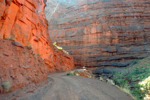
The single-track Fisher Towers Trail has rock pavement and dirt. It is well-marked and simple to follow, with cairns or rock piles to indicate the route. On hot days, plan your hike accordingly, as there is no shade along the trail. Remember to wear a hat, apply sunscreen, and carry lots of drinks.
How To Find The Fisher Towers Trailhead
From Moab, head north on US 191 and turn right (east) onto UT 128/River Road immediately before the Colorado River Bridge. Travel 21 miles on this paved route until you reach a Fisher Towers turnoff. To reach a parking lot and campground, turn right (south) and travel another 2 miles southeast on a gravel road.
What Time is The Busiest?
The Fisher Towers Trail tends to be busiest during the spring and fall months, particularly in April, May, September, and October. During these times, the weather in Moab, Utah, is generally more moderate, with cooler temperatures than summer’s scorching heat. Many visitors prefer to explore the trail during these seasons to avoid extreme temperatures and enjoy the desert landscape’s vibrant colors.
Additionally, weekends and holidays can be particularly crowded, as more people have time off to visit popular outdoor destinations like Fisher Towers. If you prefer a quieter experience on the trail, consider visiting during weekdays or early morning or late afternoon hours when fewer visitors are needed.
Flying A Drone (Is It Allowed?)
Yes, drones are allowed to be flown in Fisher Towers. However, we highly recommend that you leave your drones at home. Privacy, aviation safety, and wildlife protection are the three main areas of concern.
Some people were startling the wildlife by trailing herds of wild creatures, which caused them to alter their behavior and leave the region. Drones also contribute significantly to noise pollution in cars with strong bass. It can be annoying to have a loud machine buzzing around when you’re enjoying the outdoors in a remote location.
Other Hikes Close To Fisher Towers Trail
In addition to the Fisher Towers Trail, there are several other hiking and outdoor recreational opportunities near Fisher Towers in Moab, Utah. Here are a few notable trails and areas to explore:
Onion Creek Trail
- Level: Moderate
- Length: 11.4 miles
- Estimated Time: 4 hours and 27 minutes
The roads are broad and buff, with the exception of those that cross streams, making navigation simple. Remember to pack your camera because this trail offers some of the most breathtaking views of Red Rock. Aside from being a great spot for Moab mountain biking, you also might want to consider UTV and ATV rentals for a more enjoyable exploration.
At the summit, which is reached after 26 stream crossings and a steady, moderate ascent, you’ll be rewarded with vistas of the La Sal mountain range and Fisher Valley Ranch. Due to the road’s excellent maintenance, it’s possible to come across cars, cows, and 4WD vehicles.
Professor Creek/Mary Jane Canyon
- Level: Moderate
- Length: 7.6 miles
- Estimated Time: 2 hours and 43 minutes
Twenty miles northeast of Moab, Professor Creek is a small stream that empties into the Colorado River. The creek runs year-round along Mary Jane Canyon, a shallow ravine for most of its course, but becomes fairly narrow and up to 100 feet deep, about one mile in the center. Unlike most real slot canyons, the walls feature unique rock textures and hues because the rock is tougher, darker, and less striated.
Since much of the excursion involves paddling in the cool, shallow water, the upstream trek is a leisurely stroll that’s especially enjoyable in the summer. Abundant green flora along the creek’s banks contrasts nicely with the reddish canyon walls.
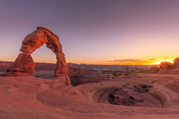
Delicate Arch Trail
- Level: Moderate
- Length: 3.2 miles
- Estimated Time: 1 hour and 35 minutes
Many visitors to Arches National Park travel from all over the world, and visiting Delicate Arch is a top priority for many. This free-standing arch is one of the most famous natural formations worldwide and a widely acknowledged symbol of Utah.
The word “Delicate” originally appeared in a January 1934 report about the Arches National Monument Scientific Expedition, referring to “the most delicately chiseled arch in the entire area.”
What to Bring On Your Hike
When embarking on a hike to Fisher Towers in Moab, Utah, it’s essential to come prepared with the right gear and supplies to ensure a safe and enjoyable experience. Here’s a list of items to bring along for your Fisher Towers adventure:
Sunscreen: Sun protection is paramount when hiking in the desert, especially along the Fisher Towers Trail, where there is virtually no shade. Bring a high-SPF sunscreen and apply it liberally before and during your hike to prevent sunburn and protect your skin from harmful UV rays.
Appropriate Footwear: The terrain around Fisher Towers can be rugged and rocky, so sturdy hiking shoes or boots with good traction are essential. Opt for footwear that provides ankle support and has thick, durable soles to navigate the uneven terrain comfortably and reduce the risk of injury.
Plenty of Water: Hydration is key when hiking in the desert, particularly in hot and arid conditions. Be sure to carry ample water to stay hydrated throughout your hike. It’s recommended to bring at least one gallon of water per person for a day hike to Fisher Towers, as there are no reliable water sources along the trail.
Snacks and Food: Pack lightweight, energy-boosting snacks and meals to fuel your hike. Trail mix, granola bars, fresh fruit, and sandwiches are all excellent options for sustained energy during your trek. Avoid foods prone to melting in the heat, and pack out any trash to keep the trail pristine.
Hat and Sunglasses: Protect your face and eyes from the harsh desert sun by wearing a wide-brimmed hat and UV-blocking sunglasses. These accessories will help shield you from direct sunlight and reduce the risk of sun-related health issues such as heatstroke and eye damage.
Weather-Appropriate Clothing: Dress in lightweight, breathable layers that wick moisture away from your body to stay cool and comfortable on the trail. Long sleeves and pants can provide added protection against sun exposure and abrasions from rough terrain. Consider bringing a lightweight rain jacket or windbreaker in case of unexpected weather changes.
First Aid Kit: Carry a basic first aid kit containing essentials such as adhesive bandages, antiseptic wipes, blister pads, pain relievers, and any personal medications you may need. Be prepared to treat minor injuries and ailments while on the trail.
Navigation Tools: While the Fisher Towers Trail is well-marked, it’s always a good idea to carry a map, compass, or GPS device to help you navigate the terrain and stay on course. Familiarize yourself with the trail route before setting out, and be prepared for any unexpected detours or obstacles along the way.
What People Are Saying About Fisher Towers Trail

Reviews of the Fisher Towers Trail in Moab, Utah, are overwhelmingly positive, with visitors often expressing awe at the stunning natural beauty and unique rock formations found along the route. Here are some common remarks people say about the trail:
The hike was very pretty. I believe we were almost to the end but decided to turn back because you had to walk along a very steep drop-off to get there. We were ok with the rest of the climbing but we don’t do steep drop-offs. I would still recommend the trail as long as you know what you are in for. What we saw was very pretty.
DC – Tripadvisor
Really nice hike! Listed as hard but it is just a harder moderate. A steady climb throughout without anything too extreme. The spike in the trail profile is a ladder. It only has 5 or 6 rungs and is very sturdy and anchored into the rock. Fantastic views around every corner. I strongly recommend this one!
Stephen Foster – AllTrails
One of the things I love about the Moab area is that we always find a new trail to hike that blows our minds. Fisher Towers was that hike for us this trip. Fisher towers is located just east of Moab and it’s famous not only for the stunning hiking trail that overlooks these insanely massive towers, but also for rock climbers! I love that, especially early in the day, you’ll get to see climbers on their way up and even perched atop formations that seem impossible to stand on top of!
Paige – For The Love Of Wanderlust
Fisher Towers Trail: Views Like No Other
Hiking Fisher Towers Trail is an extraordinary experience for some, if not most. The last view, beyond every tower, is surreal. Beyond the main rock fin that forms the backbone of the Fisher Towers, the terrain truly opens up to reveal untamed mountains and mesas covered in bush.
But the real beauty is in turning around and facing your original direction. From this vantage point of the Fisher Towers, you may see amazing views of the Colorado River’s sweeping curves and the mesas that stretch beyond it. You will genuinely never, ever forget the southwest scenery.
Fisher Towers Trail FAQs
Where are the Fisher Towers?
Fisher Towers is located near Moab, Utah, in the United States. They rise prominently from the desert landscape along the Colorado River corridor, approximately 16 miles northeast of Moab. The area is accessible via State Route 128, also known as the River Road, which offers stunning views of the towers as you approach the trailhead.
How tall are the Fisher Towers?
The Fisher Towers are a series of towering sandstone rock formations, with some of the tallest spires reaching heights of up to 900 feet (274 meters). These majestic monoliths dominate the skyline and are renowned for their impressive vertical stature and striking geological features.
What are the names of the Fisher Towers?
The Fisher Towers consist of several prominent rock formations, each with its own unique name. Some of the most well-known towers include:
– The Titan
– The Cobra
– Ancient Art
– The Kingfisher
These are just a few of the named towers within the Fisher Towers complex, each contributing to the area’s reputation as a world-class destination for rock climbing, hiking, and sightseeing.