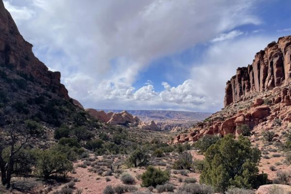
Mill Creek Trail is a popular hike that passes through a stunning canyon before arriving at a number of tiny waterfalls with swimming holes. Located near the famous town of Moab, which serves as a gateway to numerous outdoor adventures in the region, Mill Creek Trail offers hikers an immersive experience in the striking landscapes of the American Southwest.
The natural oases in Mill Creek Trail provide a refreshing respite, particularly during the hot summer months. Hikers often take advantage of the opportunity to cool off in the creek’s crystal-clear waters, making for a memorable and rejuvenating experience. It’s time for you to experience it!
Table of Contents
Map Of Mill Creek Trail
About Mill Creek Trail
- Trailhead Address: Powerhouse Lane, Moab, UT 84532
- Trailhead GPS: 38.5619, -109.5169
- Amenities: Public parking lot, portable toilet, swimming, and dog-friendly
- Level: Moderate
- Length: 1.6 miles
- Estimated Time: 31 minutes
Mill Creek Trail is the perfect hike in Moab on a hot day. It is relatively easy overall. You are immediately rewarded with a breathtaking creek and waterfall, but the hike will definitely get you wet.
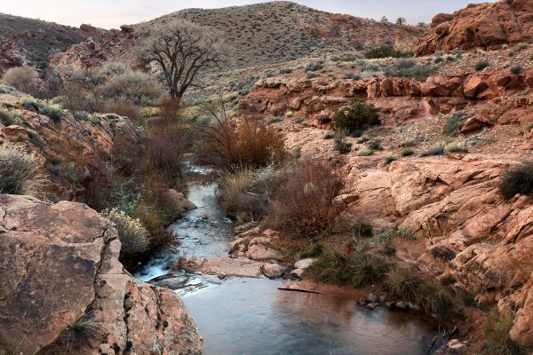
The entire route essentially meanders alongside the creek with very little elevation gain. There’s even a considerable quantity of shade and flora!
The summer months at Arches and Canyonlands National Parks can bring long days with triple-digit highs. In those circumstances, a simple swim in a chilly creek might be just as fulfilling as visiting any of the fantastic attractions in those parks. Take a pleasant swim in Mill Creek instead of the rapid and muddy Colorado River around Moab.
Guided Tour Of Mill Creek Trail
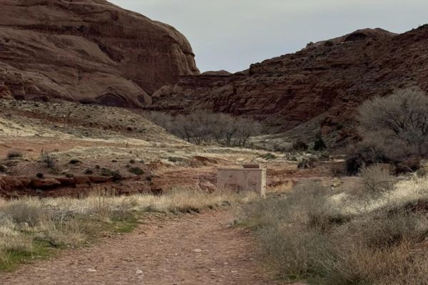
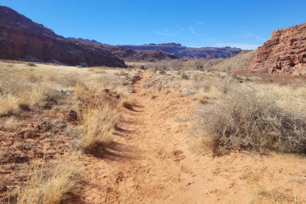
Reaching this riverine sanctuary just requires a quarter-mile stroll down the Mill Creek Trail, which leads southeast of Moab deep into the Utah landscape. Head northeast from the trailhead parking area to begin the Mill Creek route. Ignore any trails that veer left toward the creek and continue eastward along the broad dirt route.
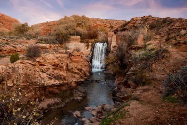
After traveling around 800 feet, you will reach the base of a tiny waterfall at the location of an abandoned power station. To go around the falls on the right (south), you will walk down a narrow slickrock shelf next to the creek and utilize a slickrock ledge to climb around the cement block dam. The traction along the angled shelf could be difficult for some people. If that’s the case, you can wade in the creek.
Like the Corona Arch trail, the route has a few challenging areas. The first one you come to immediately is one where you have to balance your way along the bank of the creek while practically clutching the walls.
The canyon soon opens, and a decent trail follows the south side of the creek across plains covered in sage and grass. Halfway up the north canyon wall, notice the tiny alcove with the dark background up ahead.
At 0.5 miles, the canyon veers to the right. Petroglyphs can be seen by peeking into the black desert patina that covers the small alcove’s interior. Binoculars or a camera with a zoom lens can help you see more clearly.
The canyon narrows at the point where the North Fork of Mill Creek and the South Fork of Mill Creek meet, with the South Fork splitting to the right. Once you find a spot to cross the creek’s north bank, proceed eastward along the North Fork of Mill Creek. Some sizable boulders bearing petroglyphs are on the creek’s south bank, a short distance beyond the junction.
For future generations to appreciate all of the rock art you find, always treat it with respect. Rock art is incredibly brittle and prone to harm. Avoid touching rock panels, as the oil in your fingers might hasten the degradation of the artwork. Don’t damage the panels by rubbing them down or adding contemporary embellishments. Leave artifacts such as shards of pottery where you find them if you come upon them.
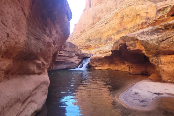
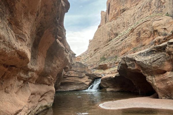
At 0.8 miles, a well-trod path climbs the creek’s north bank and leads to a sizable pool underneath a high sandstone ledge. A lovely waterfall descends the ledge’s right side. You won’t be alone at the pool because it’s a favorite spot for the locals to cool down and unwind.
Since climbing around the falls is impossible, reverse course and retrace your steps around 100 yards to a trail that ascends slickrock ledges on the canyon’s north side and passes through forests. This is the falls’ bypass trail.
Ascending and winding along slippery rock ledges, the bypass trail passes a pleasant overlook above the falls. The walk continues up the canyon’s north side past the falls, where you may leave the people behind.
A sizable alcove on the canyon’s north side will be visible after approximately one mile. The alcove with the petroglyphs and pictographs should be accessible to hikers who are accustomed to climbing slippery rock ramps. Beyond the alcove, there are other petroglyphs.
The track becomes somewhat trickier after the first swimming hole.
Reach a second, sizable pool that is obstructing your progress at 1.5 kilometers. You can discover a bypass trail on the canyon’s north side that climbs around the obstacle to avoid the pool by going back a short way. For pictographs, search a low alcove on the canyon’s north side, approximately 0.4 kilometers beyond the second pool. A few additional figures and crimson handprints can be seen here.
The canyon veers to the southeast at the 2.0-mile point. Look for a little slot canyon along the north wall as you make your way around the curve. Scale slippery rock ledges to investigate the slot and a neighboring rock-art-free alcove. The next half mile of the canyon is a picturesque area featuring towering sandstone walls. This is a favorable turning point.
Hikers who want to spend more time exploring the canyon can do so. The trail now spans benches, avoiding the streambed other than to cross over to the opposite side. Here, the walls are lower, and the canyon expands. After 4.0 kilometers, reach the intersection of Mill Creek and Rill Creek. This is yet another excellent turning point.
On your return trip to the trailhead, search the canyon walls for further petroglyphs. It’s certainly warm enough by now to enjoy a quick dip in one of the pools or just to pull over on a ledge and enjoy the shade and stunning canyon scenery.
Hiking ends when you reach the creek, and then it’s time for a swim. Mill Creek has some tranquil pools, and there’s enough flow to propel you down a couple of rock water slides.
If you plan to swim at the waterfall, look into the pool to identify any shallow areas before plunging over the cliff. Additionally, never dive in headfirst.
If you go upstream, you might witness a few daredevils leaping off a cliff into the pool at the foot of the falls. Jumping is not the best option because the deep spot is rather narrow (unless you know a good doctor in Moab for broken legs).
What To Expect on Your Hike
Mill Creek is on BLM territory. Dogs are allowed and can be off-leashed in some areas. The road toward the trailhead is restricted to certain vehicles: No buses, trailers, or RVs are allowed. There is parking, but the vehicle length limit is 22 ft.
In order to manage overflow parking and limit visitors, new regulations are in place along Powerhouse Lane (parking may not be available when you come to hike).
Watch out for the poison ivy that grows abundantly in this area. Even if you are wearing pants, try to avoid brushing up against it. The oil spreads to other areas, such as your car seats, if it gets on anything.
Get out and enjoy Mill Creek; there is no admission charge or need for a permit.
How To Find The Mill Creek Trailhead
Take Route 191 south from Moab’s downtown. Turn left on Sage Avenue and then immediately right on Holyoak Lane. After two blocks, turn left onto Mill Creek Drive. Go half a mile, then make a right onto Powerhouse Lane. Travel 0.3 miles on this route to reach the parking lot at the end of the road.
Avoid parking on private property or along Powerhouse Lane, where it is prohibited, and instead utilize the public lot.
What Time is The Busiest?
Be ready to see hundreds of people on Mill Creek on weekends during the summer. It gets crowded quickly because it’s so accessible; if you want to enjoy a peaceful hike and the sounds of the stream, wake up early in the morning. The best times to hike this trail are April through July.
Flying A Drone (Is It Allowed?)
Flying drones in national parks is prohibited, and Mill Creek Canyon is part of the Manti-La Sal National Forest, which may have its own regulations regarding drone use. It’s essential to check with the local authorities or the managing agency, such as the U.S. Forest Service, for the most up-to-date information on Mill Creek drone regulations and surrounding areas.
If you’re considering flying a drone in Mill Creek, I recommend contacting the appropriate authorities beforehand to inquire about any permits or restrictions that may apply. Respecting these regulations ensures the safety of wildlife and other visitors and helps preserve the area’s natural beauty for future enjoyment.
Other Hikes Close To Mill Creek Trail
Before or after having the most refreshing swim in Mill Creek, you might want to consider hiking nearby trails, which offer stunning views as well.
Grandstaff Canyon Trail

- Level: Moderate
- Length: 5.7 miles
- Estimated Time: 2 hours and 30 minutes
A popular half-day hike in the Moab area, the Grandstaff Canyon Trail is named after William Granstaff, an African-American prospector who grazed animals in the late 19th century. This trail offers a beautiful journey through a stunning canyon embellished with towering red rock walls, rich foliage, and the cool waters of a permanent stream. It is located close to Moab in southeast Utah.
Morning Glory Natural Bridge, a magnificent 200-foot-long sandstone arch that is among the biggest in the region, is one of the trail’s highlights.
Hidden Valley Trail
- Level: Moderate
- Length: 6 miles
- Estimated Time: 2 hours and 56 minutes
There are two faces to the Hidden Valley Trail, an amazing adventure trek amid the cliffs just south of Moab. The first 0.6 mile of the trail is a steep ascent of about 600 feet and is rugged, rocky, and challenging. Above that, the single-track trail levels out on a smooth dirt surface with gentle hills until it approaches Hidden Valley.
If you take your time climbing, you’ll be rewarded with beautiful views, tranquility, and an exquisite rock art panel.
Pinyon Interpretive Loop

- Level: Easy
- Length: 1 mile
- Estimated Time: 21 minutes
Currently a self-guided nature trail, this path covers the world of desert ecosystems. You’ll come across some intriguing tales of relationships in the high desert. The mailbox at the trailhead contains brochures.
The landscape consists of sandy washes interspersed with rocky outcrops. Observe cairns and signage to avoid getting lost. The serene moments and breathtaking “Shark Fin” views are the best parts.
What to Bring On Your Hike
When preparing for a hike on the Mill Creek Trail in Moab, Utah, it’s important to bring along the right gear and supplies to ensure a safe and enjoyable experience. Here’s a list of items to consider:
Water: Staying hydrated is crucial, especially in Moab’s desert environment. Bring an ample supply of water to last throughout your hike. A hydration pack or water bottles can be convenient options.
Sun Protection: Protect yourself from the strong desert sun by wearing sunscreen, sunglasses, and a wide-brimmed hat. Consider bringing sunscreen with a high SPF rating and reapplying it regularly.
Appropriate Footwear: Waterproof shoes are a great choice, considering you may encounter water features along the trail. Sturdy hiking boots or trail shoes with good traction are also recommended for navigating rocky terrain. Don’t forget to pack extra socks in case your feet get wet.
Hiking Poles: Bringing hiking poles on your trek along the Mill Creek Trail in Moab, Utah, can be a beneficial addition to your hiking gear, especially considering the varied terrain and potential obstacles you may encounter.
Snacks/Packed Lunch: Pack lightweight, non-perishable snacks such as trail mix, energy bars, or dried fruit so you’ll have something to snack on before, during, or after swimming in Mill Creek’s clear waters. You can also have your own lunch picnic there. Make sure to dispose of your trash properly!
Emergency Supplies: For unexpected situations, include items like a whistle, flashlight, or headlamp with extra batteries, a multi-tool or knife, and a lightweight emergency blanket.
Insect Repellent: Mosquitoes and other insects may be present, especially near water sources. Apply insect repellent to exposed skin to minimize bites.
Camera/Smartphone: Use a camera or smartphone to capture the stunning scenery and memorable moments along the trail. Just remember to secure it properly to prevent damage.
Trash Bag: Over the last ten years, Mill Creek has seen an increase in the number of visitors—perhaps too many. As a result, there is now more trash, graffiti, and other environmental damage to the park and nearby properties. Make an attempt to lessen the impact of your stay, and bring your own trash bag when hiking.
What People Are Saying About Mill Creek Trail
With its features, the Mill Creek Trail offers many people a refreshing hike. It’s one of the best things to do in Moab if you’re visiting during summer. Here’s what people are saying about this hike:
This is a great dog-friendly trail that is a very short drive from anywhere in Moab. We went late morning and there were very few people there. The Rim Trail takes you up the hill and you can make your hike as long or as short as you want.
Rachel V – AllTrails
When I hiked this trail in mid April, the deepest the creek was at the crossings was probably to my ankles. I’m not going to say that it was pleasant continuing to hike with soaked shoes, but I can imagine on a hot day it must feel pretty nice!
Kylie Bearse – Approachable Outdoors
If it is a hot day in Moab, Mill Creek is THE place to be. This is a beautiful and very social place in the hotter times of the year. Is it considered the local swimming hole, and a nice relaxing place to beat the heat. The hike in is beautiful, casual, short, and family friendly. Highly recommended if in the area.
Road Trip Ryan
Refresh and Rejuvenate Along Mill Creek Trail
One of the highlights of Mill Creek Trail is its abundance of water features, including small waterfalls, cascades, and pools. While some sections may be relatively easy and suitable for families with children, others present more challenging terrain, requiring careful navigation and sturdy footwear. Regardless of your skill level, you’re bound to find plenty of opportunities to immerse yourself in the breathtaking scenery and unique geological formations along Mill Creek Trail.
In addition to hiking, Mill Creek Trail is also popular among mountain bikers and trail runners seeking an adrenaline-fueled adventure amidst Moab’s iconic red rocks. The diverse landscape and well-maintained trails make it an ideal playground for outdoor enthusiasts of all kinds.
Mill Creek Trail FAQs
How long is the Mill Creek trail in Moab?
The length of the Mill Creek trail can vary depending on which specific route or section you choose to hike. The main Mill Creek trail is approximately 6.5 miles (10.5 kilometers) one way, extending from the trailhead near Moab to the La Sal Mountains foothills. However, there are shorter options available, and hikers can choose their desired distance based on their preferences and abilities.
Can you swim at Mill Creek in Moab?
Yes, you can swim in Mill Creek in Moab, particularly at certain points along the trail where the creek widens into pools or forms small cascades and waterfalls. These natural swimming holes offer a refreshing way to cool off during warmer months. Always assess the water depth and current before swimming, especially after heavy rainfall or snowmelt when water levels may be higher.
How were the waterfalls formed on Mill Creek Trail?
The waterfalls along Mill Creek Trail in Moab were formed through a combination of geological processes, including erosion and sediment deposition. Over thousands of years, the flowing water of Mill Creek gradually carved through the surrounding sandstone, creating channels, pools, and cascades. The presence of natural barriers, such as resistant rock layers or debris, can also contribute to the formation of waterfalls by redirecting the flow of the creek and creating picturesque cascades.