
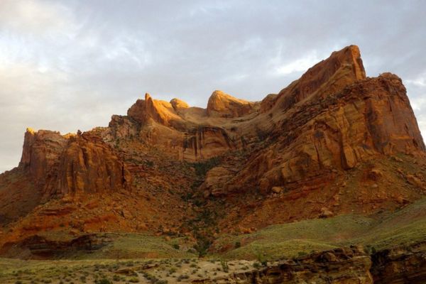
Wanna know the best hikes in Canyonlands National Park? There are actually numerous hiking trails spanning hundreds of kilometers, crisscrossing the park’s natural and cultural attractions.
The park is divided into four sections: The Needles and Island in the Sky offer lots of options for quick strolls, full-day treks, and backpacking excursions. The Maze is mostly a trekking attraction because of its secluded location. And, of course, the rivers themselves.
The park is open all year round, although certain facilities could close in the winter. You can definitely find the ideal route for your next visit to Canyonlands National Park, no matter what your plans are for the day.
Map of Hikes in Canyonlands
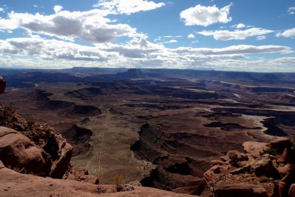
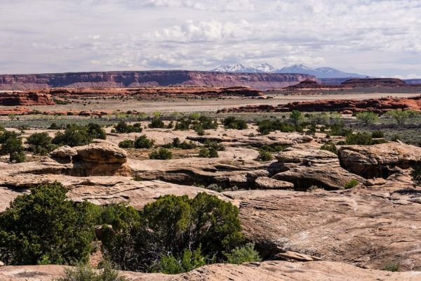
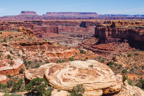
Island In The Sky Canyonlands Hikes
All trails at Island In The Sky are marked with small rock piles. You should bring enough water that would last you, depending on the trail level you’re taking on. Avoid hiking here during the peak heat of summer days. Remember to bring essentials like a flashlight, map, and basic first aid kit.
Murphy Point Trail
- Level: Easy
- Length: 3.4 miles
- Estimated Time: 1 hour and 9 minutes
You might find the Murphy Point Trail appealing if you’re looking for a lengthier, relatively level hike than a mile. It gets you away from the road and the sounds of cars and lets you imagine what Canyonlands looked like when it was a ranch before it was made a national park.
A historic corral on the summit of the mesa is passed by on this hike. At the end of the trail are expansive vistas of the White Rim Road, the Green River, and Candlestick Tower.
Nice easy out and back trail that is relatively flat. There is an old coral. Murphy’s point has a spectacular Vista that includes Green river. We liked the solitude. We started at 8:30 and didn’t see anyone else until we were alnost back to the trailhead
robertmaster123 from Tripadvisor
Neck Spring Trail
- Level: Moderate
- Length: 5.5 miles
- Estimated Time: 2 hours and 18 minutes
Along this loop trail, you’ll see old ranch structures and two springs where cowboys used to water their animals. There are times when this road is rough and uneven. You have to walk up and down a rocky hill and stone steps. There may be snow or ice in the winter, so we hikers are advised to bring traction devices.
Great hike through random terrain, lots of hills and scenery, just under 6 miles. This was our last hike after 4 days of hiking. This is appropriate for anyone that has some level of conditioning. And a perfect way to end or start if you plan on doing harder hikes before or after.
whosgoingtobali from Tripadvisor
Wilhite Trail
- Level: Hard
- Length: 11 miles
- Estimated Time: 5 hours and 19 minutes
A rough trail with lots of sharp turns leads down 1,600 feet (488 m) into a long, shallow wash. The White Rim Road is at the end of the wash. You won’t see many other people while you’re taking on this trail. It’s great for backpacking, camping, and hiking.
As part of our 4-day backpacking adventure, we hiked Wilhite Trail down (and I do mean “down”) to White Rim Road. A small brown sign on the side of the road indicates where to park, and rock cairns (stacks of rocks) indicate where to hike once you’re out on the trail. We didn’t get lost at all, but we did have to pay attention to the rock cairns quite a bit.
Brittany_11_10 from Tripadvisor
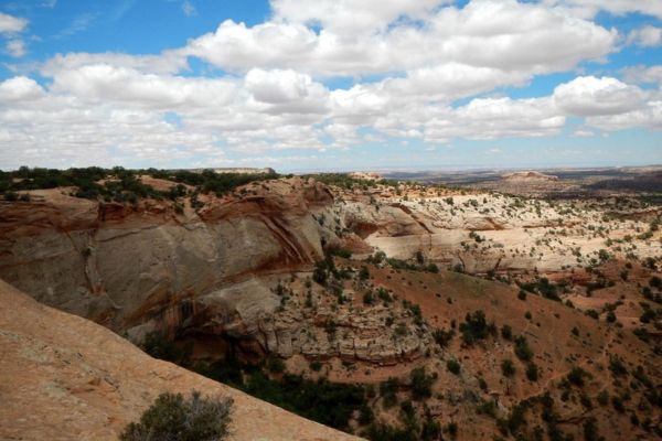
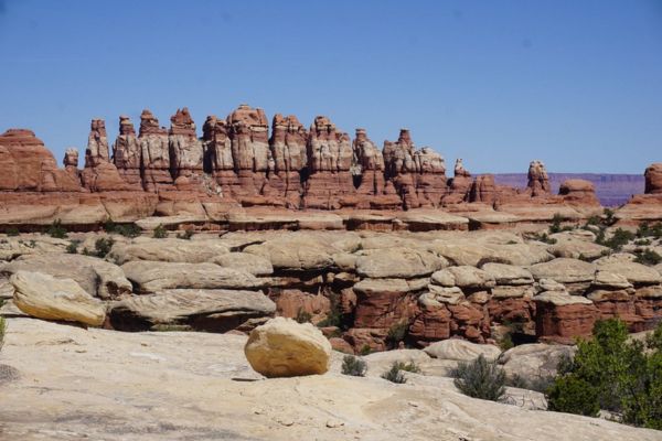
Best Hikes in the Needles Canyonlands
Over 60 miles of interconnected, challenging, and rewarding trails may be found in The Needles. There are a plethora of possible itineraries; the following list includes some of the most popular ones. At the trailheads and the visitor center, there are trail guides available.
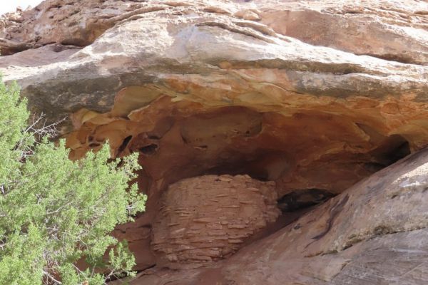
Roadside Ruin Trail
- Level: Easy
- Length: 0.3 miles
- Estimated Time: 5 minutes
This trail has one of the oldest structures in the park that has been kept in the best shape. It was built maybe more than a thousand years ago.
Native plants that people use to meet their daily needs can be seen along the short walk. They will help you understand how the early inhabitants of this area lived.
Please remember that archeological sites must not be entered, touched, or climbed on at any cost. To protect the fragile structures, only look at them from afar.
It only takes a minute to walk to this grainary left from past residents of the canyon. It’s a quick hike and a fun thing to see.
Melissa D from Tripadvisor
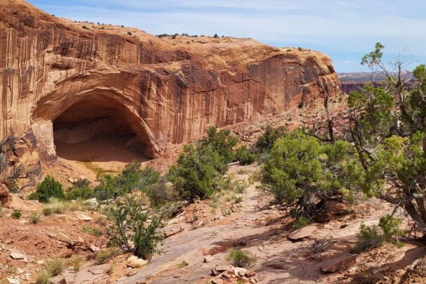
Cave Spring Trail
- Level: Moderate
- Length: 0.6 miles
- Estimated Time: 14 minutes
You can start a short loop walk here that will take you to an old cowboy camp and prehistoric rock carvings. To finish the route, you will have to climb two stairs. This is important to know if you’re hiking with kids.
As you walk along Cave Spring Trail, pay attention to how the water has affected each spot.
This is a nice, flat walk, with the exception of the ladders. Even if you don’t climb the ladders, the walk is very nice. Climbing the ladders gives you a new perspective of the district.
Senioronabudget from Tripadvisor
Chesler Park Loop Trail
- Level: Hard
- Length: 10.2 miles
- Estimated Time: 2 hours and 45 minutes
You’ll start this trail at the Chesler Park / Joint Trailhead and take on its various sections along the way. Some campsites are in the backcountry, and there are also signs of ranching that used to happen in Chesler Park before it became a national park. The viewpoint is only a quarter mile from the main trail, and the short walk up to a smooth rock platform with a picture-postcard view of Chesler Park and the sandstone formations around it is well worth it.
If going to Needles District this is where the Needles formations are and it is stunning. Very remote, need to be in excellent physical shape to do the trail out there and the loop.
dronesonata from Tripadvisor
Canyonlands Day Hikes
If you’re keen on spending your day hiking challenging trails, here are some Canyonlands day hikes that are perfect for you.
Druid Arch Trail
- Level: Moderate
- Length: 9.7 miles
- Estimated Time: 5-7 hours
One of the most beautiful views in The Needles can be found on this path. It starts on the first part of the Chesler Park trail and then splits off to go through deep sand and loose rock along the bottom of Elephant Canyon. At the top, the last 1.25 miles are steep and include one ladder and some climbing.
One of the most unusual arches I’ve ever seen. The views are also great in all directions including back down the canyon we just came from. It was a perfect place to grab a bite and to relax as the sun started to go down behind the arch. We sat there for good long time drinking everything in…
kevan j from Tripadvisor
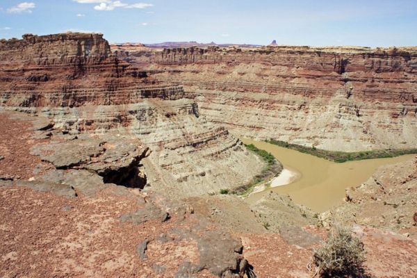
Confluence Overlook Trail
- Level: Moderate
- Length: 10 miles
- Estimated Time: 5-6 hours
This trail is different from other Needles hikes because it goes through dry, open land along the northern edge of the geologic faults that formed the Needles. At the end of the path, there is a cliff with a view of where the Green and Colorado rivers meet.
what can really be said about something so magnificent. the hike is just a hike but the views are spectacular. such a unique geologic feature.
Jay D from Tripadvisor
Syncline Loop
- Level: Hard
- Length: 7.9 miles
- Estimated Time: 5-7 hours
The Syncline Loop Trail goes around Upheaval Dome, but there are no views of that interesting rock formation. It has steep curves and requires climbing and scrambling through boulder fields. This is the toughest trail in the Island in the Sky area, and it’s also where most park rescues happen.
If you hike the path counterclockwise, it starts with a very steep descent. However, the gradual ascent through miles of loose sand offers better shade in the afternoon.
Trail is a bit tricky in places. We were told by Park Rangers that there are more emergency rescues from Syncline Loop than any other hike in the Park. Probably mostly from sprained ankles, etc. Views are breathtaking. All in all, life changing.
bill w from Tripadvisor
Alcove Spring Trail
- Level: Hard
- Length: 11 miles
- Estimated Time: 6-7 hours
A lot of people like to backpack and hike on this road, but you can still get some alone time during the day. The trail is beautiful all year, so you can go at any time. The trail goes down past a big nook and then winds through a wide canyon to the base of the famous Moses and Zeus towers.
Hiked in late April 2023. A great way to experience solitude in an otherwise busy part of Canyonlands. Easy hiking once you are down in the wash, there are a few pictographs around once you get to Moses and Zeus. Beautiful expansive views.
Nathan Mahan from AllTrails
Best Family Hikes in Canyonlands
Planning to bring your kids for Canyonlands hike? The park also has family-friendly and kid-friendly trails. Whether you have a 10-year-old who loves the outdoors like you or a teenager who’s seeking that adrenaline rush, Canyonlands has everything to offer.
Mesa Arch Trail
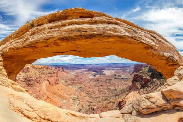
- Level: Easy
- Length: 0.7 miles
- Estimated Time: 17 minutes
This arch sits on the edge of the mesa’s top and surrounds views of the river below and the La Sal Mountains in the distance. If you go around the loop and walk counterclockwise, there is a little more elevation change at the start. To cut down on stairs, go around the tunnel in a clockwise direction and then go back the way you came.
A lot of people take pictures of the Mesa Arch. They come here in the morning to wait for the sun to shine on the bottom of the arch.
I wasn’t expecting the arch to be on a cliff side! The drop off was so cool and the view through the arch was spectacular! It wasn’t busy either only one other person was enjoying the area when we showed up 😊
Cheyenne Rae from Tripadvisor
Upheaval Dome First Overlook via Crater View Trail
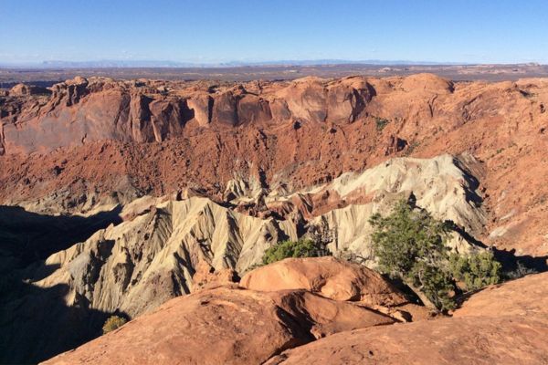
- Level: Moderate
- Length: 0.7 miles
- Estimated Time: 19 minutes
Canyonlands has a general order to its geology. Layers of sedimentary rock carefully record past events that happened in the park. With a few notable cases, these layers haven’t changed much in terms of tilts, folds, or changes in shape in millions of years.
But Upheaval Dome has a very different story. There is a big change in the shape of the granite layers, which is about three miles (5 km) across. In the middle, the rocks are pushed up into a ring shape called an anticline or a dome. This dome is surrounded by a syncline, which is a downwarp in the rock layers.
What caused the dome to fold up in the Upheaval? At the end of the walk, there are displays that talk about this unique geological structure.
You can only view this only by doing a hike. There are 2 observation points; we heard the first overlook was sufficient, so we went there. The view is amazing and there’s still a mystery how this was actually formed.
Dean_Amy-2004 from Tripadvisor
Slickrock Foot Trail
- Level: Moderate
- Length: 2.4 miles
- Estimated Time: 49 minutes
When you have half a day to spend in the Needles District, the Slickrock Foot Trail is a great way to enjoy it, regardless of how much experience you have hiking. A lot of the trails in the Needles go along the sides of canyons, but this one stays high and gives you a view of the whole southeast corner of Canyonlands National Park.
Beautiful trail with lots of great view points! Be sure to follow the cairns closely, as there are some parts where it’s easy to miss them and get turned around. Beautiful day, no ice or mud.
marisa pashby from AllTrails
Best Short Hikes In Canyonlands National Park
If you already have an action-packed itinerary or just want to experience hiking in Moab for a bit, these short hikes in Canyonlands National Park are just perfect. Even though it’s only a short walk, the views you will see are still breathtaking!
Grand View Point Overlook
- Level: Easy
- Length: 0.1 miles
- Estimated Time: 2 minutes
At the very end of the Island in the Sky beautiful drive, in the south, is Grand View Point. From this spot, you can see miles of wavy valleys, the White Rim four-wheel-drive road, parts of “The Maze” and “The Needles,” and mountains in the distance.
A beautiful view can be reached by a short, paved path. You can walk another mile to get to a second sight from that point. At Grand View Point, park rangers often give geology talks from spring to fall.
Amazing views looking down to valley, basins, and canyons. Take the Grand View Point trail all the way to the lookout around 3 miles return for non stop vista’s.
CanuckAlberta from Tripadvisor
Shafer Canyon Overlook
- Level: Easy
- Length: 0.3 miles
- Estimated Time: 9 minutes
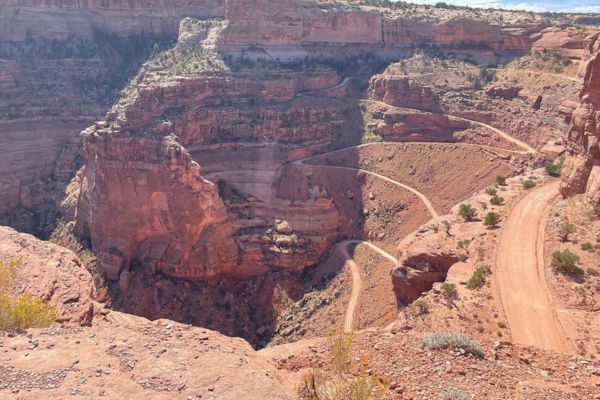
The famous Shafer Trail in Canyonlands National Park’s Island in the Sky area goes down a colorful, huge sandstone cliff.
Native Americans built it as a way to get resources on top of the mesa. Later, it became a trail for shepherds to move their flocks to better winter foraging areas. Finally, it became a road for trucks to bring uranium from the backcountry to the market. The Shafer Trail is now a difficult, unpaved backcountry road for tourists looking for the adventure of a lifetime.
This was my favorite overlook in Canyonland. It was just stunning and so impressive. The colors and geological rock formations are worth your time to take a look and admire this natural beauty
DLP from Tripadvisor
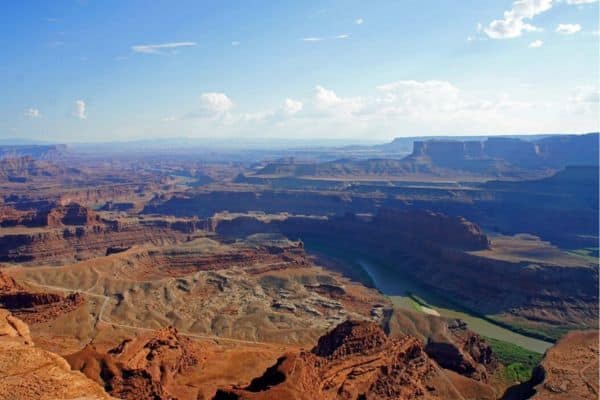
Green River Overlook
- Level: Easy
- Length: 0.2 miles
- Estimated Time: 4 minutes
The best view of one of Canyonlands’ two big rivers is from this southwest-facing vantage point, with the Green River 1,300 feet (396 m) below, deep in its course. People can also see parts of the White Rim Road and The Maze area. This is one of the best places at Island in the Sky to watch the sun go down.
This is amongst our favorite viewpoints in Canyonlands. The overlook is a very short walk from the parking lot along a paved path and leads to a beautiful view of a canyon carved by the river. This overlook is a must see.
Anthony from Tripadvisor
Experience Great Hikes In Canyonlands National Park
As the biggest national park in Utah, Canyonlands National Park spans a huge area. Hiking above and into Canyonlands, renowned for its finely carved canyon, is a must-do activity for any itinerary traveling through Utah.
The Needles District is the main hiking destination in the park and the hub for well-maintained trails. Similar well-maintained trails can be found at Island in the Sky, but this time, they’re perched high atop a mesa sandwiched between the Colorado and Green rivers. Not to mention, The Maze is a well-known location for experienced backpackers despite being a barren and isolated area with no services for 50 miles in any direction.
Whichever area of the park you visit first, don’t forget to include these fantastic hiking trails on your agenda for the next trip.
Hikes In Canyonlands National Park FAQs
What is the best hike in Canyonlands National Park?
The best hike in Canyonlands National Park is subjective and depends on personal preferences and hiking abilities. However, some popular hikes include the Mesa Arch Trail, Grand View Point Trail, and the challenging but rewarding Syncline Loop Trail.
What are the famous landforms in Canyonlands National Park?
Canyonlands National Park is renowned for its stunning geological features, including vast canyons, towering mesas, natural arches, spires, and buttes. Some famous landforms include Mesa Arch, Island in the Sky, The Needles, and The Maze.
What is the longest trail in Canyonlands National Park?
There are a few lengthy trails at Canyonlands National Park. Salt Creek Canyon spans 22.5 miles, and expert backpackers need to do the hike overnight. Some other long trails are Lower Red Lake Canyon, Wilhite Trail, and Chesler Park.
What is the most famous arch in Canyonlands National Park?
The most famous arch in Canyonlands National Park is Mesa Arch. It’s an iconic natural arch perched on the edge of a cliff in the Island in the Sky district of the park. Mesa Arch is especially popular for its stunning sunrise views, framing the distant canyons and mesas in a beautiful orange glow.