Moab Monsoon Safety: Read Sky & Radar
Planning a desert trip is exciting, and you absolutely can enjoy Moab in monsoon season if you understand how storms and flash floods work here. This guide to Moab monsoon safety walks you through what the monsoon is, how to read the sky and radar, and how to choose safer hikes, drives, and campsites when storms build.
Table of Contents
Moab Monsoon Safety Basics
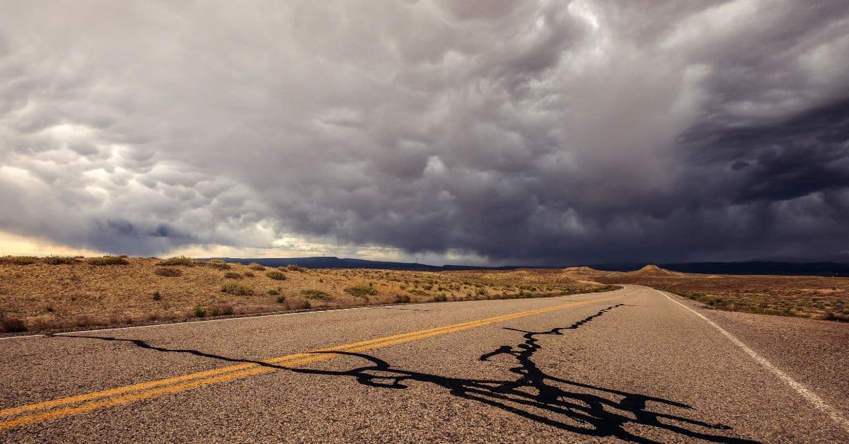
In Utah, “monsoon season” usually runs from mid-July through September, when moisture pushes up from the south and feeds almost-daily chances for thunderstorms.
Around Moab, that means:
- Hot, sunny mornings
- Puffy white clouds turning tall and dark in the afternoon
- Fast-building thunderstorms with intense downpours, gusty winds, lightning, and sometimes hail
Moab’s canyon country is highly flash-flood prone because:
- The soil is dry and compact, so rain can’t soak in quickly.
- Bare sandstone and slickrock shed water like pavement.
- Canyons and dry washes funnel water into narrow choke points.
Big points to remember:
- It doesn’t have to be raining on you for a flash flood to hit. Runoff can race down from storms miles away and appear under blue sky.
- Floods move fastest and most violently in:
- Slot canyons
- Dry washes and gullies
- Canyon mouths and narrow road cuts
- Flash floods often develop within a few hours of heavy rain.
Your job is to:
- Know when storms are likely.
- Know what terrain collects water.
- Adjust your plans when the two overlap.
Watch Forecasts
Checking the forecast is your first line of defense. Do it the night before and again the morning of your outing.
Key Forecast Terms
Look at the National Weather Service (NWS) point forecast for Moab and for the specific park or trail area you’ll visit. Pay attention to: NOAA National Severe Storms Laboratory
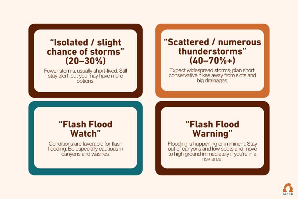
Utah tourism and park sites often post flash flood potential ratings and remind visitors:
- Don’t enter slot canyons if storms threaten.
- Don’t camp in wash bottoms.Visit Utah
Turn the Forecast Into a Plan
A simple way to think about it:
- Green-light day
- Low storm chances, no watches or warnings.
- Longer hikes are possible, but still avoid narrow slots late in the day.
- Yellow-light day
- Scattered storms, or flash flood watch in the region.
- Choose shorter hikes, go early, avoid slots and big drainages, keep backup plans ready.
- Red-light day
- Numerous storms, strong monsoon surge, or flash flood warning nearby.
- Skip canyon hikes. Stick to high, open terrain close to town or simply take a rest day, visit museums, or scenic drive with frequent weather checks.
How to Read the Sky
Forecasts are step one. Watching the actual sky is step two. Here’s what to watch for during the day:
Early Signs (Time to Pay Attention)
- Puffy white clouds growing tall and cauliflower-shaped (towering cumulus)
- Darkening cloud bases, especially to the south, west, or over the La Sal Mountains
- A distant thunder rumble
If you can hear thunder, you are close enough to be struck by lightning and should move toward safe shelter (building or hard-topped vehicle).
Escalating Signs (Time to Change Plans)
- A visible “wall” of rain or virga (rain falling but evaporating before it hits the ground) moving your way
- Sudden cool wind gusts out ahead of distant storms
- Clouds forming a broad, flat “anvil” spreading east from a thunderhead
If storms are forming or moving anywhere upstream of your canyon or wash, treat that as a serious warning and get to higher, open ground.
Practical Habits
- Check the sky every 15–20 minutes, not just at trailheads.
- Set a turnaround time that gets you out of any drainage or canyon before typical afternoon storm time.
- Build the habit: “Hear thunder? Time to head for the car or a sturdy building.”
How to Use Radar Apps
Radar sounds intimidating, but you only need a few basics for day-to-day trail decisions.
Most weather or radar apps show reflectivity images: colors that indicate where rain is falling and how intense it is. Higher reflectivity (yellows/reds) usually means heavier rain and greater flash-flood potential.
Simple Radar Routine for Moab
- Before leaving town
- Open your radar app and center the map on Moab.
- Set the range so you can see roughly 50–100 miles around (La Sals, Abajos, Book Cliffs, San Rafael area).
- Watch the loop
- Tap the play/loop button.
- Note:
- Where storms are right now
- Which direction they’re moving
- Whether new storms are popping up over the same area (called “training” storms), which can cause serious flooding
- Match radar to your plan
- Identify where your hike or drive sits relative to storm clusters.
- If strong cells are lined up upstream of your canyon or wash, don’t go in, even if it’s not raining at the trailhead.
- Check again during the day
- If you have service, check radar at:
- Trailheads
- Major junctions
- Before dropping into any canyon or large side wash
- If you have service, check radar at:
If radar and the sky don’t agree (radar looks fine, but the sky looks ugly where you are), trust the sky and choose the more conservative option.
Slot Canyon Risks
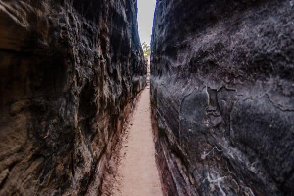
Slot canyons near Moab are beautiful, but they are the most dangerous place to be during a flash flood.
What makes them so risky:
- Narrow walls: Water has nowhere to spread out, so it stacks up vertically.
- Few or no exits: Sheer walls make escape nearly impossible once water rises.
- Debris: Floods carry logs, branches, and rocks that can pin or injure you.
Even a small amount of rain in the upstream drainage can send a wall of water and debris surging into an otherwise dry slot.
Simple Slot Canyon Rules
- Do not enter a slot canyon if:
- Storms are in the forecast anywhere in the area.
- Radar shows active or building storms upstream.
- There is a flash flood watch or warning affecting that region.
- Only consider slots when:
- Forecast shows low storm chances and stable conditions.
- You start early and are out of the drainage by late morning.
- You fully understand the canyon’s drainage area and escape options.
Safer Choices on Stormy Days
When monsoon storms are likely, skip the slots and instead:
- Walk rim trails and viewpoints well away from cliff edges.
- Explore short hikes close to town with easy, dry exits.
- Visit Arches or Canyonlands overlooks but stay out of deep, narrow drainages.
You still need lightning awareness on high ground, but the flash-flood risk is much lower than inside a tight canyon.
Driving and Camping Tips
Flash-flood danger isn’t just for hikers. Roads and campsites can be hit too.
Roads and 4×4 Routes
- Never drive through a flooded dip or wash.
- As little as 6 inches of fast-moving water can knock a person off their feet, and 12–18 inches can carry away many vehicles.
- You don’t know if the road bed has been washed out beneath the muddy water.
- Follow the rule: “Turn around, don’t drown.”
- If a road sign or ranger has closed a road or trail for flooding, respect the closure; conditions may be worse than they look from your angle.
For off-road drivers:
- Study maps to see where your route crosses washes or canyons.
- Have a realistic exit strategy if crossings become uncrossable.
- Don’t commit to remote roads on days with strong monsoon storms in the forecast.
Camping in Monsoon Season
- Never camp in a wash, gully, or low spot, even if it’s bone-dry on arrival. Those channels exist because they’ve flooded before.
- Pitch your tent:
- On higher benches or gentle rises
- Well away from canyon mouths
- Away from the outside edge of meanders where water undercuts banks during floods
- Give your vehicle a safe parking spot too; don’t park in wash bottoms.
If heavy rain is expected overnight, consider developed campgrounds or lodging in town instead of remote backroads camps.
What to Do in an Emergency
Even with good planning, weather can surprise you. Here’s what to do if things go wrong.
If you see water rising or hear a flood coming
- Don’t wait. Move immediately.
- Go to higher ground, aiming for slopes or benches 30–100 feet above the water if possible.
- Move perpendicular to the flow, not downstream along it.
- Abandon packs or gear if they slow you down. Your life is worth more than equipment.
- Stay off unstable slopes that may slide when saturated.
If someone is caught in floodwaters:
- Do not enter the water to attempt a rescue if it is moving swiftly.
- From a safe place, call 911 (or local emergency number) and look for ways to throw or extend aid (rope, stick) without entering the flow, if that can be done safely.
Lightning safety in open desert
When thunderstorms are in the area:
- The safest place is a fully enclosed building or a hard-topped metal vehicle with the windows up.
- Avoid:
- High points, ridgelines, and cliff edges
- Isolated trees or tall single objects
- Metal fences and open shelters
- If you’re caught in the open with no better option:
- Move away from high ground and isolated trees.
- Spread your group out by 20+ feet to reduce multiple injuries.
Stay in shelter until 30 minutes after the last thunder.
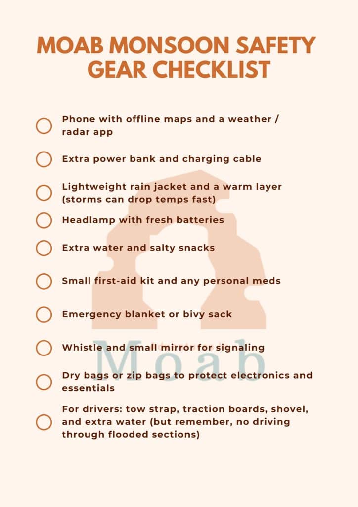
Monsoon-Ready Gear Checklist
Pack with storms in mind:
Final Thoughts
Respecting Moab monsoon safety doesn’t mean avoiding summer trips; it means reading the sky, reading the radar, and choosing terrain that fits the day’s weather.
Check forecasts, stay flexible, avoid slots and washes when storms are around, and you can enjoy red rock sunsets, cool post-storm air, and a safe, memorable trip to canyon country.
Moab Monsoon Safety FAQs
Is it safe to hike in Arches or Canyonlands during monsoon?
Yes, with good planning. Pick routes that stay on higher ground, avoid deep or narrow drainages, start early, and keep hikes short on stormy days. Check forecasts, watch the sky, and be prepared to cut your hike short if storms build.
How far away can a storm still cause a flash flood where I am?
Storms many miles upstream can send water racing into your canyon or wash, even under blue skies. Flash floods often occur away from where the heaviest rain actually falls, especially in canyon country.
Do I really need a radar app, or is the regular forecast enough?
You can do a lot with just the NWS forecast and watching the sky, but a radar app adds a clear picture of where storms actually are and where they’re moving. That’s especially helpful if you plan to be in or near drainages, or out all day.
What if I booked a canyoneering tour and the forecast looks stormy?
Talk with your guide or outfitter. Reputable guides will monitor forecasts and radar and change plans or cancel if flash-flood risk is too high. If you’re uncomfortable with the forecast, say so. In canyon country, it’s always better to lose a day than to gamble with a flood.