Your Essential Guide to Fins and Things One‑Way Trail
The Fins and Things one-way trail is one of Moab’s most accessible and scenic slickrock trails, perfect for first-time visitors in stock 4x4s or UTVs. Located in the Sand Flats Recreation Area, this one-way loop offers steep fins, grippy sandstone, and iconic desert views—without requiring hardcore mods or expert skills.
This guide covers everything you need to know before you drop in: entrances, fees, obstacles, gear tips, and the exact direction of travel to stay safe and legal on this popular Moab route.
Table of Contents
Quick Facts
| Item | Detail |
| Location | Sand Flats Recreation Area, Moab, Utah. |
| Trail type & directionality | One‑way only for the main 4×4 route. |
| Distance | Approximately 9.4 miles (≈15.1 km) according to Grand County trail log. Typical drive time: 2‑4 hours depending on stops and vehicle. |
| Elevation range | Starts around 4,700 ft (≈1,435 m) and climbs in places; see terrain section for specifics. |
| Difficulty rating | Moderate‑to‑difficult for stock rigs; slickrock, sand, steep climbs & descents. Suitable for high‑clearance 4×4/UTV; stock is possible with caution. |
| Vehicle types | Stock 4×4s, UTVs, side‑by‑sides. Note: long‑overhang rigs may struggle. |
| Closest services | Moab (fuel, supplies) ~10‑15 minutes away. Cell coverage intermittent on the trail. |
| GPS start/finish coordinates | Start near the park entrance: 38.581638, ‑109.500229. Finish reconnects to Sand Flats Road near main entrance station. |
Entrances

- Start from the town of Moab: Head east on S 400 E / Mill Creek Drive, then continue onto Sand Flats Road into the Sand Flats Recreation Area.
- Main Entrance Station (Sand Flats Road) – pay the day‑use fee and signage will point you toward the trailhead for Fins & Things one‑way route.
- Trailhead Turn‑off – The official access point for the Fins & Things 4×4 trail is located about 1.8 miles from the entrance station on the right (south side) of Sand Flats Road.
- GPS approx: ~38.58231, ‑109.50303 for the turn.
- Trailer / UTV staging: Park trailers in the designated parking area before entering the turn‑off.
- GPS approx: ~38.58231, ‑109.50303 for the turn.
- Additional note – Some sources mention a slightly different entrance for the northern loop or variant. Always follow signage.
Day‑Use Section
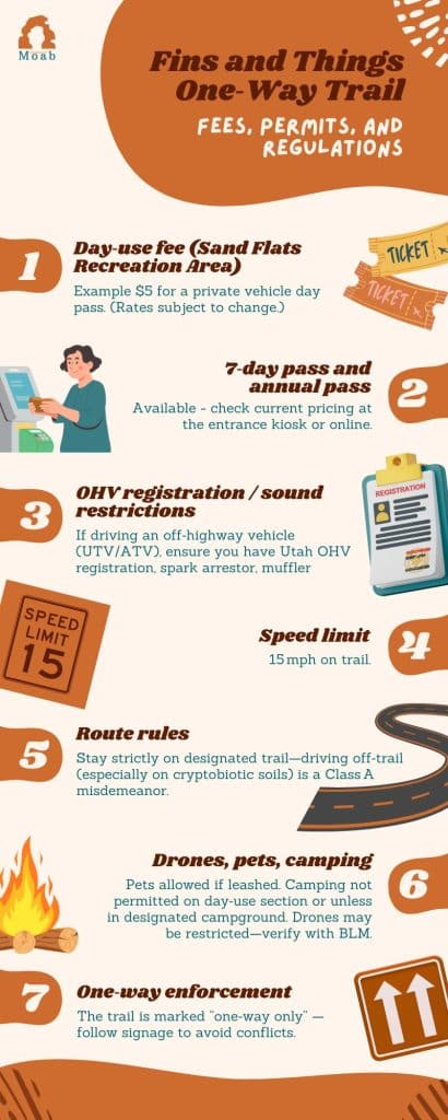
- Day‑use rules: Section south of Sand Flats Road is “day‑use only” (no overnight access) and is limited to the hours from ½ hour after sunrise until ½ hour before sunset.
- Payment: Pay at the Sand Flats Recreation Area entrance station (or kiosk) for vehicle pass. Accepted passes include day passes, 7‑day, annual (check current rates).
- Re‑entry: Confirm whether you’re allowed to re‑enter the same day if you exit the area—usually yes if you keep the pass/tag visible. (Check the day of your visit.)
- Enforcement: Rangers monitor one‑way flow, stay on designated route, and can issue fines for off‑trail travel.
- Seasonal or holiday exceptions: The defined hours may vary—for example winter daylight hours are shorter. Arrive early.
Facilities
- Restrooms: Vault toilets are located at various campground clusters and at trailhead / parking lots in Sand Flats.
- Water: No potable water available on‑trail for Fins & Things one‑way; carry your own water.
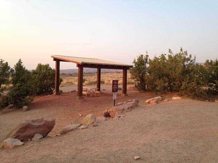
- Shade & picnic: At the parking/staging area near the entrance you’ll find improved shade structures and a picnic area. The Sand Flats Rec Area recently added parking and a picnic shade at the lower Raptor Route exit.
- Dump stations / RV services: Accessible at the main Sand Flats Recreation Area campground loops; check in at the entrance for locations.
- Emergency services: Nearest emergency services in Moab. On‑trail cell coverage is spotty—plan accordingly.
- Maps/offline: Download offline maps (GPX) or use apps (e.g., onX Offroad) because cell may drop out mid‑trail.
Trail Overview and Direction of Travel
The trail is officially one‑way—vehicles must follow the direction of signage and white painted symbols on the slickrock.
You’ll enter from Sand Flats Road, follow posted trail markers on slickrock fins and sand, and eventually exit back to Sand Flats Road near the entrance or a designated exit point.
- Why one‑way matters: This flow ensures traffic isn’t meeting head‑on on narrow slickrock fins. Trying to go the wrong way is dangerous and may violate park rules.
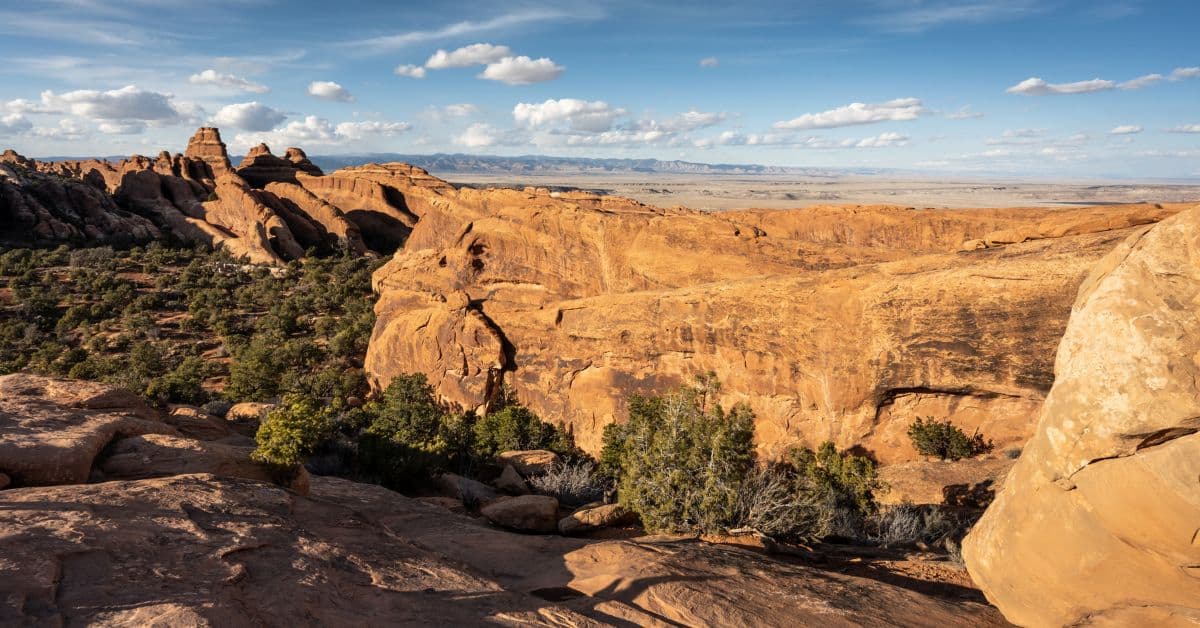
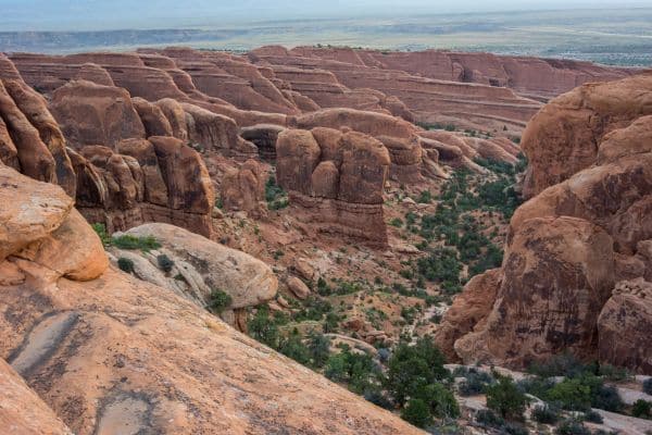
- Terrain: Expect slickrock fins (solid Navajo sandstone domes and ridges), sand washes, steep climbs and descents, occasional rock ledges, and narrow sections.
- Traction advice: On slickrock you’ll actually get good grip if you maintain momentum and proper tire pressure; sand sections require slower speed and caution. Airing down helps.
- Recommended direction: Most guides suggest the counter‑clockwise flow starting near Campground E toward the west/north side loop for smoother traffic and exit logistics.
Vehicle Requirements and Driving Tips
- Minimum requirements: High‑clearance 4×4 drive is strongly recommended. Stock rigs can manage but expect tighter margins. Some sources say “minimum tire size 33 inches or greater” helps in sand and overhangs.
- Ground clearance: The slickrock fins and ledges can exceed 12–18 inches of relief—make sure undercarriage and overhangs are protected.
- Tire pressure: For slickrock and sand, drop tire pressure to ~18‑22 psi (or lower if large tires) depending on load—gives better traction and ride comfort.
- Use of 4‑Low: On steep climbs or descents, engage 4‑Low gear and keep steady momentum; avoid abrupt throttle changes.
- Spotting and teamwork: On tight slickrock ridges or steep drops, one spotter outside the vehicle is a smart idea.
- Rental / UTV notes: If you’re in a rental UTV, ensure it’s properly insured and rental company allows sand/slickrock use. Follow size/width restrictions (some narrow fins may be tight for wide rigs).
- Overhangs & approach/departure angles: Turn slowly, avoid steep sharp drop‑offs unless confident.
- Momentum management: On slickrock transitions, avoid hard braking—let the vehicle roll gently and trust the traction.
- Tread: All‑terrain tires will work; aggressive mud‑terrains help in deeper sand. Stock road tires will increase risk.
Obstacles and Notable Waypoints
Here are key spots along the Fins and Things one‑way route. Use them as visual checkpoints.
- Start Turn‑Off from Sand Flats Road (~Miles 0.0) – turn right into trail entrance ~1.8 miles from entrance station according to signage.
- Slickrock Fin Drop & Climb (~Mile 0.8) – Trail drops off a fin to the right then climbs again; may require careful wheel placement.
- Intersection Fox/Hawk Campgrounds (~Mile 1.4‑2.4) – Trail passes through or alongside campground areas; respectful driving required.
- Diving Board Rock / Cattle Guard (~Mile 3.5‑4.1) – Narrow section just after Cattle Guard; traffic caution.
- Porcupine Loop Intersection (~Mile 4.1) – You’ll pass the turn‑off to the Porcupine Rim Trail; stay on Fins & Things.
- Lunch Overlook Canyon (~Mile 6.7) – Large canyon view, good photo stop. Use turnout off main line.
- Final Slickrock Fin Climb & Descent (~Mile 7.3‑8.6) – A series of slickrock ridges and drops where signage can be confusing—stay on marked symbols.
- Exit to Sand Flats Road (~Mile 9.4) – Trail rejoins the main road; turn right to return to entrance station.
Pro Tip: On the slickrock fins, follow the painted white dots/symbols rather than tire tracks—those marks indicate the approved one‑way route.
Fees, Permits, and Regulations
Best Time to Go and Weather
- Spring (March‑May): Pleasant temperatures (50‑75 °F), mild crowds—excellent for slickrock.
- Summer (June‑August): Hot midday temps (90 °F+); early start recommended.
- Fall (September‑October): Cooler, lovely light on the rocks, moderate crowds.
- Winter (November‑February): Cooler weather (30s‑50s °F), possible snow/ice on slickrock—extra caution required.
- Rain/monsoon: Flash‑flood risk in washes; slickrock becomes slick and hazardous if wet—avoid when wet.
- Crowd patterns: Weekends are busy, especially late morning; arrive early for best conditions and fewer vehicles.
Safety, Recovery, and Etiquette
- Recovery gear checklist: Tow strap, soft shackles, compressor, plug kit, first‑aid kit, recovery boards, gloves.
- Yielding norms: On narrow slickrock ridges: uphill vehicle has the right‑of‑way; if you’re descending and get stuck, back out or spot. Stay alert for other vehicles.
- Leave No Trace: Stay on trail, avoid driving over cryptobiotic soil (very fragile). Pack out trash, respect vegetation.
- Emergency plan: Tell someone your route and expected return time. Carry offline map/GPS; cell service is unreliable.
- If you must turn around: Do so only where trail allows widening; don’t attempt a reverse on a narrow fin. Better to back out cautiously than risk damage/collision.
- Etiquette: Keep comms clear if part of a group; wait at turnouts for others; respect campers at campground intersections.
Nearby Trails and Alternatives
- Hells Revenge 4×4 Trail: More advanced slickrock, steep climbs—one step up in difficulty from Fins & Things. Good if you finish early and want more.
- Porcupine Rim Trail: Longer, higher elevation, stunning canyon views—great full‑day adventure combination.
- Gemini Bridges Trail: Easier and shorter side‑trip for lighter rigs or if you want less technical.
- Combining trails: Start Fins & Things in the morning, then switch to Hells Revenge or Porcupine Rim for afternoon, return to Moab by sunset.
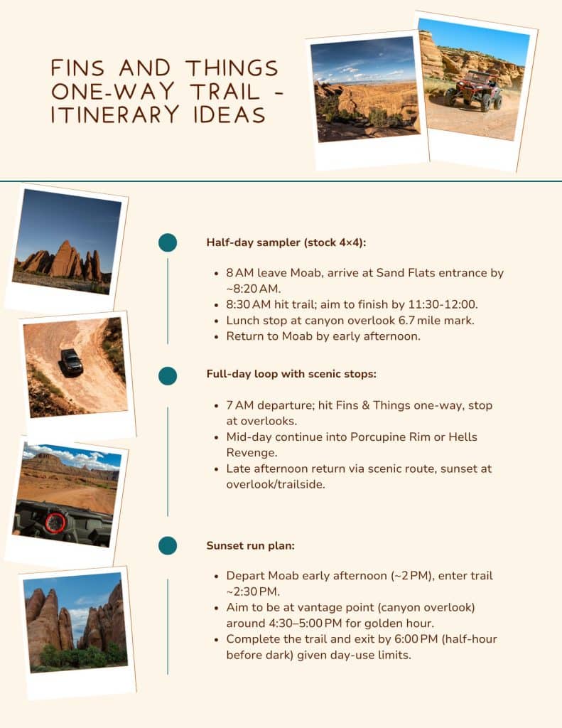
Itinerary Ideas
What to Pack
Required gear:
- Water – minimum 1 gallon (≈4 L) per person.
- Sun protection – hat, sunglasses, high‑SPF sunscreen.
- Offline map/GPX – Download ahead.
- First‑aid kit, flashlight/headlamp.
- Tire pressure gauge and air compressor.
- Tow strap, shackles, recovery boards.
Nice‑to‑have gear:
- Camera/drone (if allowed) for slickrock fins.
- Snacks/lunch for overlook stop.
- Portable shade or umbrella for long stops.
- Extra layer for evening chill.
Fins and Things One-Way Trail FAQs
Can a stock 4×4 complete it?
Yes, with proper care, tire pressure, and slow spotting it’s doable—but high‑clearance and good tires make it far more comfortable.
Can I drive it in the rain or snow?
Driving slickrock when wet is risky—traction drops dramatically. In snow/ice, only attempt if equipped and experienced. Avoid if unsure.
How crowded does it get and how to avoid traffic?
Weekends and mid‑day are busiest. Arrive early (before 9 AM) or go mid‑week for fewer vehicles.
Are trailers allowed at the staging areas?
Yes, but best to park trailers in the designated lot before the trail head turn‑off so you’re not obstructing staging.
Verify Before You Go
- Confirm current day‑use fee and pass rates at Sand Flats Recreation Area entrance.
- Check trail status/closures (weather, maintenance, BLM alerts).
- Verify one‑way direction rules and signage on the day of your trip.
- Confirm UTV/ATV registration & OHV rules for your vehicle type.
Check weather forecast for your day (slickrock is hazardous when wet).